module9

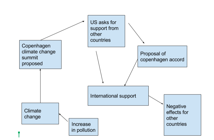
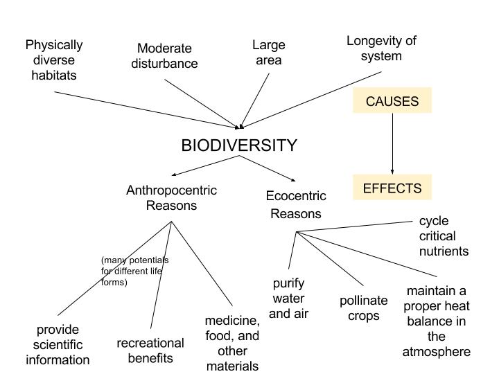
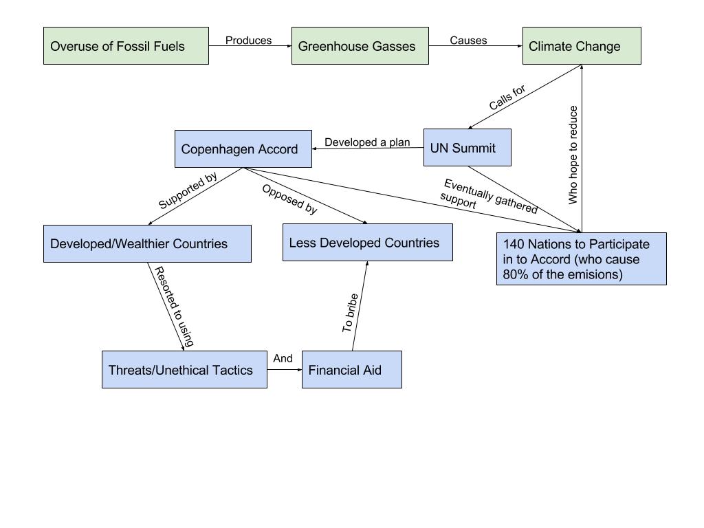
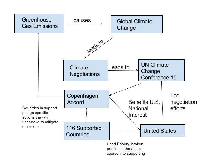
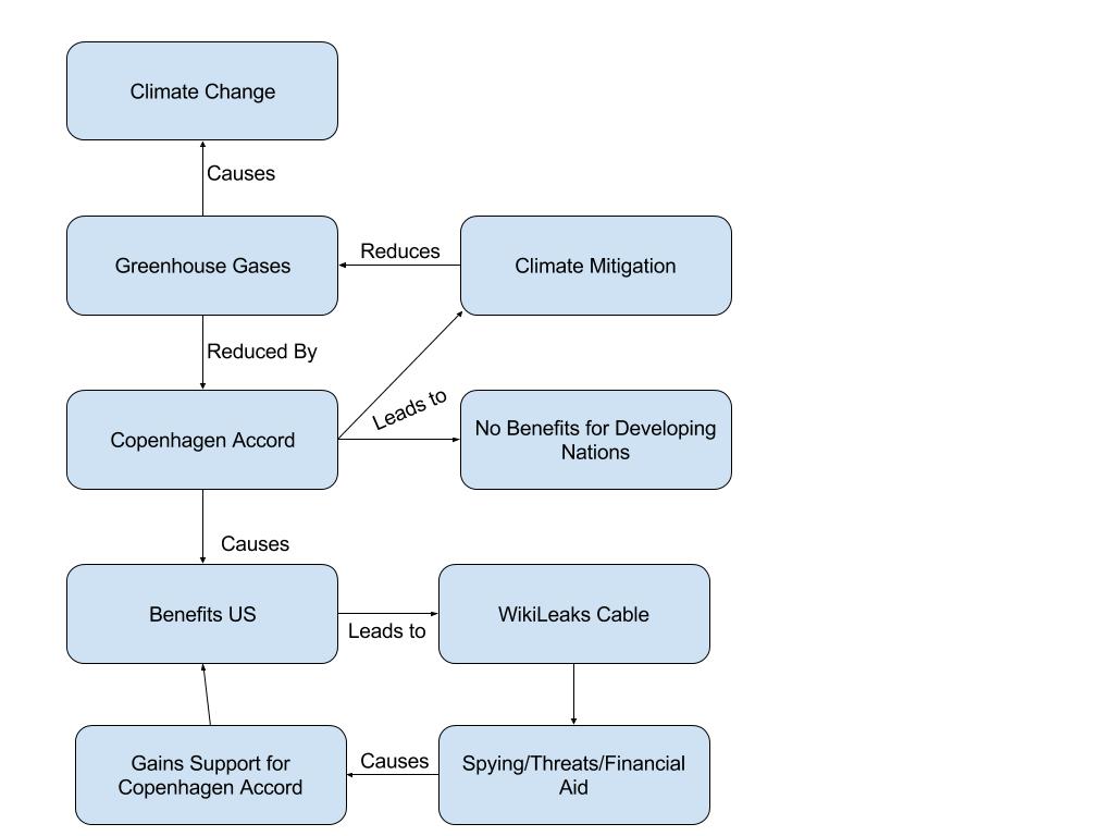
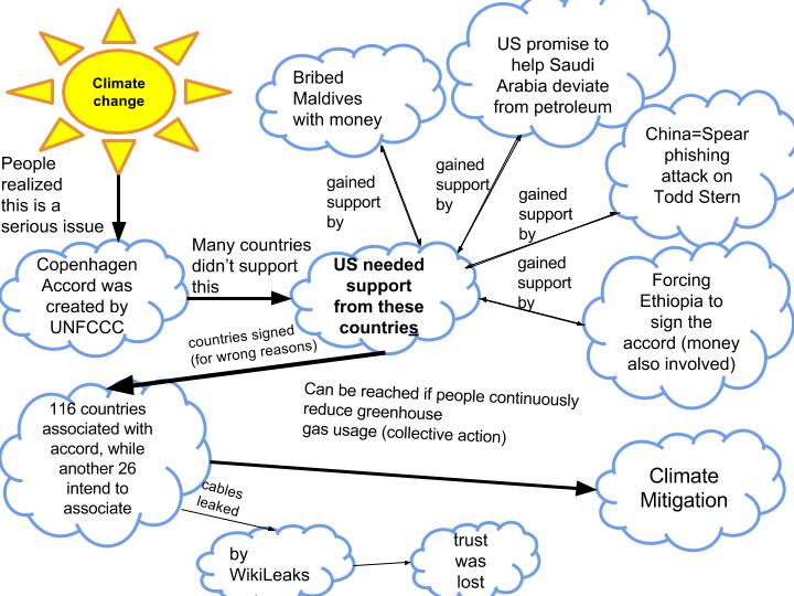
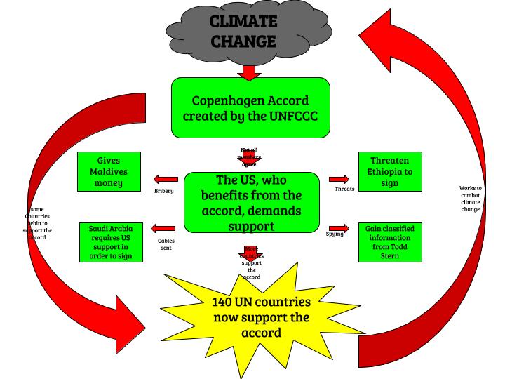
After reading about the Copenhagen accord, I created a diagram of the system in which the problems have started from and what they have created. It is evident that the main cause of the problems that are being face now are the climate changes that have occurred due to air pollution and increased emission from greenhouses. Once this evidently became a problem, the Copenhagen Climate Change Summit was created in 2009. The United States was in full support of this, which led to other countries also agreeing to support it as well. However, it took some bribing from the U.S. for the countries to agree because the Copenhagen Accord needed more countries to sign and support it. After bribing many other countries, 140 countries were in support of the Copenhagen Accord. This resulted in many changes in other countries, and fortunately for the United States, they could keep up with these changes due to the U.S. being a wealthy country. On the other hand, however, these other countries that cannot afford to adapt to these changes, are struggling in keeping up. The diagram explains how the air pollution was the beginning issue and how that resulted in climate changes that were affecting the area. In addition, that become the reason for why the Copenhagen Climate Change Summit was created. The diagram shows how there was an issue with the proposal, as there were not enough countries to support the cause. Which then results in the U.S bribing other countries for their support. Which did not end up helping these other countries, which is why there are still issues.


In my opinion, the United States was being greedy when they bribed these other countries and I do not think what they did was trustworthy or respectful. It was a selfish decision made by the country and I think that what happened as a result was fair. The U.S. using the cables as a way to get the other countries to agree was not the right way to do it. This is why I do believe that the cable’s being leaked was right for what the United States did to the other countries. The issue could have been solved in a different way. Pollution is a problem with many countries in some way.  The U.S used its economic and political power to take advantage of other countries, which is not a good way to deal with bigger problems that can be solved in other ways.

Screen Shot 2016-04-27 at 1.35.59 PM

Biodiversity – Robert Hudert

  1. Using outside sources, research and find studies of biodiversity in or near your hometown. Briefly describe the study, its purpose and problems that are being found in relation to H.I.P.P.O.

Scientists examine biodiversity of Passaic River Parkway in Union County’s annual Bio-Blitsz (Link: http://www.nj.com/news/index.ssf/2011/06/union_county_hosts_annual_bio-.html)

Union County, New Jersey is home to many concerned citizens as well as a county owned stretch of  the Passaic River. Over the course of 24 hours in 2011, scientists and biologists were to experiment with the river. The experiment’s main goal was to release the true facts about what lives in the river. The plan is that over the course of these 24 hours, the scientists will shock the water with electricity in order to temporarily stun the fish and let them float to the top of the water. By doing this the scientists and community citizens will get to truly see what has moved into their area which will give them a better idea of how to maintain the waterways. The concern is that various foreign species have made their way into the area by local ports accepting imports and unknowingly bringing their own species into the area. Scientists claim it is truly sad the unknowing impact that these importers have and that it truly effects their ecosystem.

Pinelands Biodiversity Study (Link: http://www.state.nj.us/dep/dsr/publications/pinelands-final.pdf)

The Pinelands in New Jersey is home to the Northeast’s largest pinelands with almost 1500 square miles. The plan of this study was to analyze the impacts of the forest management services. The would be one area that was strictly designated as a control zone that has never had any forest management as well as a test zone with history of forest management that would serve to prove whether or not the forest management did or did not impact the overall biodiversity of the area. The study areas were vegetation surveys and avian surveys, or also referred to as bird and plant studies, respectively. The overall findings of these studies were that the forest management and human interaction in these areas did, indeed have an impact. The forest management zone had impacts of life lengths of plants as well as the increased number of non-native species due to the interaction of the humans in a place they simply do not belong.

2. Using the Pinelands study, create a diagram that shows the threats to biodiversity in the New Jersey Pinelands.

Untitled document (4)

Module 10

biodiversity_gbe5025

1.Question 1 (In 250 words): Are dense anthropocentric developments as resilient/adaptive to major change as their counterparts?
Simply put, for a variety of reasons with the most influential being economical, urban metropolises aren’t as adaptive to major “change” as ecosystems are. Especially in this modern age with a sprawling human population, the effects of this deficiency become all the more pronounced when disasters do happen. Many times when such events occur a state of emergency is declared (not trying to debate the merits of such a declaration) and external aide is quickly provided. City plans are designed on the premise that all if not a majority of the needs or services a city requires will be delivered to it rather than addressed “in house.” This type of perspective means that little if any thought goes into adequately designing space to maximize the various utilities a space may have to offer(whether vertical, on the ground, etc…). Vital services include waste management, energy generation, efficient heating/cooling biomimicry among others that can be tackled in many ways depending on the topography throughout the city. For example, a city’s skyline is usually dominated by the all too familiar block-like skyscrapers that during a heat wave can’t alleviate the increased heat efficiently without added strain on the power lines. The aggregate demand of such a scenario in addition to any unforeseen natural disasters could lead to serious issues. While most skyscrapers are constructed in a manner that minimizes costs, the city collectively would benefit from skyscrapers that mimic biology in design and function. (Such arrangements= increased weight savings, less materials needed, more sunlight exposure, better deflection of heat, etc…) Lastly, a cities’ reliance on external support means it’s prone to abrupt disruptions more so than an ecosystem because an ecosystem’s biodiversity allows for a greater carrying capacity and resiliency(=greater margin of error).

2.Question 2 (In 150 words): What can cities do to lessen the affects of major disasters/changes.
Cities can encourage developers to emphasize the services local ecosystems can provide to both the structure and it’s residents. An example could be vegetation on vertical surfaces to provide adequate water absorption, cooling, air filtration, aesthetic and physiological appeal as well. Depending on the topography, the city would best be served to have a biomass plant on high ground as a defense against flooding (if a biomass plant were to get flooded the “mass” could cause outbreaks in the surrounding area due to low hygiene treatment). Encourage local production to meet the cities’ food consumption demand (counties would have to work together to collectively create policies that benefit both) as well as having “farm space” vertically perhaps. Gradually reconfiguring street traffic for pedestrian, bicyclists and motorists use would greatly help in decongesting traffic and maximizing flow. Public parks could be multi storied to take advantage of “air space” over the conventional park on the ground surface. Also include more community-orientated places for leisure.

Module 10: Pavelko-Fox

Part 1. Draw a systems diagram representing the state at which biodiversity is changing today. Be sure to include detailed information about the reduction/conservation of biodiversity and how these factors effect it. The diagram should have at least six system components and the arrows should point in a logical direction and be explained.

Part 2. In a paragraph of 250-350 words, explain the ideas behind your diagram and connect these ideas with concepts you learned from other modules.

Part 3. In another paragraph of 250-350 words, present an example of a threat that effects biodiversity in your hometown and what steps could be taken to reduce this threat.

Screen Shot 2016-04-15 at 10.26.57 PM

2. Biodiversity plays a crucial role in the future of sustainability, this is why we must continue our efforts to conserve the environment in order for biodiversity to thrive around the world. In my diagram above I have shown some of the problems concerning the reduction of biodiversity and  the steps that have been taken in order to reverse these effects. The diagram uses contrasting red and blue text blocks to depict the problems (red) and solutions (blue). The first red block closest to the top gives a general overview of the main issues negatively effecting biodiversity. I then broke the main block down into two categories, human and non-human factors. Each of these categories contain specific examples of human and non-human factors and how exactly they are impacting biodiversity. On the other side of the diagram I have the blue blocks containing information on the conservation efforts to help grow biodiversity. Some of these efforts include a stronger push for conservation through which people use the idea a collective action to help raise awareness of reduced biodiversity around the world. Another catalyst in this conservative movement is the work The International Union for the Conservation of Nature has been doing. They’ve created a systematic scheme of the different levels of protected areas and what each of those areas means in terms of what they do for conservation. However, in order for these conservative efforts to have a greater effect, more of us need to acquire an ecocentric mindset. We can continue to develop as a species but we need to learn how to do it in such a way that protects habitats and other ecosystems while trying to gather the resources we need in order to thrive.

3. Anyone who has lived in or visited Pennsylvania, especially during the summertime, will probable be familiar with some of the many bugs that call this state home. Most bugs play an important role in the food chain and even agriculture but there is one species in particular that seems to be doing more harm then good. The Brown Marmorated Stink Bug or stink bug for short is an example of an invasive species that has been impacting biodiversity in Pennsylvania. Originally found throughout East Asia, it is speculated that the stink bug was brought over to the U.S through shipping materials and was first discovered in the late 1990s in Allentown Pa. In module 10 we learned about some of the dangers invasive species can pose to biodiversity and what it could mean if that problem isn’t dealt with. Stink bugs have been known to feed on a variety of plants, including fruit trees, ornamentals, and various other crops. Since the stink bug has no natural predators here in the U.S, they can continually cause damage to locally grown produce. So the question remains, what can we do about these pesky insects. Insecticides are one option but why spread more chemicals into the environment when there are other ways to deal with them. I have known farmers who have used mineral clay as a means of preventing stink bugs from both laying eggs and feeding on crops. Another effective way to get rid of stink bugs are to buy stink bug traps. We have used some of these traps around my home and I was amazed at how many these things could hold, there must have been hundreds of stink bugs in each one. The nice part about stink bug traps is that they aren’t polluting the environment with toxic chemicals and they are made to only attract stink bugs.

Biodiversity – Jared Mummert

1) Do you think anthropocentric or ecocentric arguments are more likely to convince the world that biodiversity is important? (200 – 250 words).

I believe that a mixture of anthropocentric and ecocentric arguments are the best way to convince people that biodiversity is important. I think that anytime something directly benefits us we are more likely to take it seriously, but if we are only concerned about what we can get from something then we are more likely to exploit the resource even further. For example let’s say that we only rely on anthropocentric arguments to preserve biodiversity. We tell people that we need to save the rain forests because the cure for some disease such as cancer may be hidden within its jungle walls. This argument holds solid until we find the hypothetical plant that contains the cure for the disease. Since we are only concerned about what we can get out of the rain forest, we will then likely cut down the entire rain forest in search of more of these plants or others like it. I believe that in order to preserve the rain forests we must consider more than our own direct benefits from it. If we hold a mixture of ecocentric and anthropocentric values, when we find the plant that contains the cure we would still value the ecosystem and its biodiversity for its own existence and preserve it.

2) What are some threats to biodiversity in your hometown or areas near you? (200 -250 words)

In this module we learned about the “H.I.P.P.O.” acronym that  accounts for biodiversity loss associated with habitat loss, invasive species, pollution, human population, and over harvesting. In my area there are a few invasive plant species such as multiflora rose which threaten to choke out native shrubs by preventing them from getting sunlight. We also have insects such as gypsy moths, emerald ash borers, Japanese bettles, and stink bugs that over-consume plants while going largely unchecked by local predatory animals. Habitat loss is another major threat to biodiversity in my area. One native species that is currently endangered due to habitat loss in my area is the bog turtle. Last summer I had an internship with a local environmental engineering consulting firm, and we had an intern on staff who’s only job was to look for bog turtles in areas where we were about to do bridge construction. If he found a bog turtle in the area we would have to redesign the bridge in a way that didn’t inhibit the bog turtle’s travel routs. My company also dealt with storm sewer water that was often polluted by salt and oil from roads. This polluted water would have to be treated so that it wouldn’t harm sensitive fish and invertebrates in the local trout streams.

3) Research a threat to biodiversity that deals with an area other than your hometown or the rainforests. Write a 150 – 200 word summary and site your source. 

I read an article that explained how rising levels of CO2 and decreasing pH in the ocean are causing shellfish to have weaker and ineffective shells. The more acidic water weakens the calcium carbonate shells of shellfish and can weaken the bones of many other marine organisms. While the higher CO2 and lower pH is bad for shell fish, it is great for algae and sea grasses that rely on CO2. This can lead to algae explosions which can choke out other marine life and cause further problems. The lower pH threatens shellfish that we consume directly such as oysters and clams, and also organisms that are food sources for salmon and other fish such as pteropods. It also threatens the coral reefs that are the hub of diversity in the ocean. The acidic sea water eats away at the limestone structures that many coral species construct, and this threatens the entire coral reef ecosystem. Clearly we can see that steps need to be taken to reduce global CO2 and prevent ocean acidification.

Module 10: Amazon Rainforest System Diagram

  1. Using Module 10- Biodiversity as a resource, draw a system diagram connecting the Case Study: The Amazon Rainforest to biodiversity. The diagram should have at least six system components and the arrows should point in a logical direction and be explained. Be sure to include plenty of detail about the study, about biodiversity, and about the impacts between the two.

geology module 10

2. In another paragraph, explain what your ideas are behind your system diagram. Be sure to include details so others know what you are trying to portray.

Based on my system diagram, I portrayed the idea of biodiversity within the Amazon Rainforest. Biodiversity is the measure of variation and richness of living organisms at a particular scale, specifically a large scale in the Amazon Rainforest. Being the Amazon Rainforest is the largest rainforest in the world, it is home to about 50% of global biodiversity. However, it is also the most threatened ecosystem in the world because clear cutting impacts it. There is a major problem with clear cutting, as it leads to climate change. Climate change also damages hundreds to thousands of established species interactions since it is very difficult to only damage one, being that thousands of many species live in trees. In the Amazon, population growth and poverty encourage poor farmers to clear new areas of the rainforest. These ideas are exacerbated further from government policies. When these farmers clear parts of the environment, it leaves very less fertile soil left to help rebuild the forest. If deforestation keeps occurring, there will be no rainforests left within about 100 years.

Connections Mod 9 – Perricone

mod 9 diagram

The network of communications is very extensive and does not seem to be entirely friendly. Leverage was used to influence different countries’ actions. The US was in direct contact with one of the leaders of the negotiations, Meles Zenawi, the Ethiopian prime minister. The meeting was between Meles Zenawi and Maria Otero, the United States Undersecretary of State. This information was discovered by Addis Ababa. The US state department attempted hacking to discover information. They sent emails to diplomats in china that copied the format of companies hoping that they would be opened because code was attached that would allow hijacking of the computer. The first attempt failed but further attempts were planned. Ahmed Shaheed showed his hand, so to speak, by sending communications to Hillary Clinton saying he wanted support. Then two months later there was further action on behalf of Maldive to push for the accord sooner and make members in the accord follow the agreed actions. The system diagram shows how all of the individual communications are connected and centered around the United States. There was illegal spying by the United States but also against it. There was communications directly to leaders of other countries. Although the communications were related to climate change and environmental issues, there is no proof that it was the main concern of the United States to have the deal that was being struck be the deal that is best for the environment. The representatives from Maldive seemed to be more focused on the environment.

As a citizen of the United States, I am very embarrassed that the government would stoup to trying to hack individuals’ computers. Especially because these individuals are not citizens and are not subject to the authority which the United States holds over its citizens and there is no reason to suspect treasonous actions from the targeted individuals. Furthermore, the inappropriate actions risks relations between the United States and China, the country of the targeted individuals as well as any country that discovers the transgression and feels strongly that it was inappropriate and immoral. The discovered spying on United States diplomat does not condone the action. Information on the government actions should have been released by the United States government sooner than happened but I understand the need for secrecy. If I was in a position within the government to release information on the transgressions of others that would put national relations at risk I would not have released any information to compromise the United States government.

The United States uses far too high a percentage of fossil fuels throughout the country and by a very high percentage of the population. This means that the United States is allowing the release of a significant amount of harmful emission into the atmosphere. This should lead the United States to want to be a leader in environmental protection and increase regulations of emissions. This group and bringing other countries into the fight will only benefit the United States. The United States should be the one pursuing the issue not making Maldive representative make repeated attempts at communication and negotiations.

David Youn Module 10

  1. Create a system diagram that relates at least one threat to the society
  2. In 200-350 words describe the system diagram.Untitled document

Overharvesting is a serious issue that has been occurring in the past and current. There are 3 main concepts that could lead from overharvesting. One of them is the increase in endangered species. By overharvesting animals for our benefits such as for food and clothing is one of the fastest ways to put species in extinction. One great example of animals that are in danger of extinction is red tuna. Especially in Japan and Korea, many people enjoy eating tuna that could potentially put these tuna into danger. By creating international laws or regulations on harvesting limited amount of red tuna may help this cause. Furthermore, deforestation is part of overharvesting. Wood is one of the popular materials to create furniture. One of the methods that we get oxygen in the environment is by trees. As most people know that without oxygen it is very difficult for non-sea animals to live on earth. Not only deforestation is critical to oxygen resource but also as food resources. For instance, cutting down apple trees will eventually cause them to go extinct. Lastly, this all sums up to one idea. That is sustainability. Both endangerment of animals and deforestation of trees lead to a decrease in sustainability. By running out of food resources it would be difficult to harvest food or have a method to eat food.


Module 10: Biodiversity

  1. Create a systems diagram that includes the causes of biodiversity and the effects of it, as well. Be able to include what factors influence biodiversity, and why it matters.Untitled document-3 

  2. In 150-200 words, provide a short analysis or explanation of your systems diagram, noting on some of its key aspects that relate to topics in Module 10.

    In my systems diagram, I chose to systematically lay out the causes and effects of biodiversity utilizing arrows to lead from one idea to another. I chose to focus on the main causes of biodiversity, and included that physically diverse habitats, moderate disturbances, large areas, and the longevity of a system all are factors that cause biodiversity. These causes include both human and non-human factors. Some human factors that affect biodiversity are negative impacts, however the relationship between humans and biodiversity is complicated. The effects of biodiversity can be divided into two different categories: anthropocentric and ecosystem reasons. While anthropocentric reasons to value diversity include the potential of the different lifeforms to provide many benefits, ecocentric reasons to value diversity are based in the idea of it having intrinsic value that does not particularly pertain directly to human uses. For example, some ecocentric reasons relate to the water, air, and atmosphere, which in turn ultimately end up affecting humans.

  3. In 100-200 words, discuss what biodiversity you observe in your hometown, relating the causes and effects mentioned in your systems diagram.

    In my hometown, Abington, PA, one of the largest negative impacts on biodiversity include deforestation and the loss of habitat due to the building of new commercial and residential area. The amount of wild animals have decreased throughout the years due to this loss of habitat, and therefore the biodiversity has unfortunately decreased as well. As human population rapidly increases, the need to expand will also increase, which will most likely take away even more habitats of the wildlife. In effect, some natural cycles will be lost or changed due to this decrease of wildlife, and may upset the balance of the ecosystem.

Module 10 – Kevin Hosterman

  1. There are a lot of threats to biodiversity in the world today. The biggest ones can be remembered by using the acronym H.I.P.P.O.: Habitat Loss, Invasive Species, Pollution, Human Population, and Overharvesting. What are the biggest threats to biodiversity in your home state? (150 – 200 words)


Biodiversity is a constantly evolving concept and is going to change whether we do anything about it or not. We can make an extra effort to slow down threats, but no matter what species will grow and some will die. I think the biggest threat in Pennsylvania to biodiversity is habitat loss. Although I don’t think it is a giant problem, I think it is the biggest of the H.I.P.P.O acronym. A large amount and variety of different species that live in Pennsylvania live in the numerous forests that span across the state. Humans are constantly cutting down these forests for our own needs. When these forests are cut down we are destroying homes of a lot of different animals. When we remove almost any animal from its natural habitat its chance of survival decreases greatly and leads to a decrease in population.


  1. What are some things that you or your state could do to minimize these threats? (150 – 200 words)


There is no way to completely eliminate all the threats to biodiversity without putting ourselves in harm’s way, but there are definitely ways to minimize it. The state of Pennsylvania could survey different forests around the state in order to collect data on different species that live where and how many live in that area. By doing this they could selectively cut down trees that would cause the least damage to diversity. Not only could they minimize it, but if they see that a certain species only lives in a certain area they could avoid accidentally killing a species of something by cutting trees in a different location.


  1. Why is minimizing threats to biodiversity important? (150 – 200 words)

Everything has its place in the world and who are humans to eliminate another species? We need biodiversity to fulfil all the requirements of this complex planet that we live on. Sometimes we are the only thing that can stop a species from going extinct. Humans are a major threat to biodiversity, but we are also one of the biggest supporters of it as well. All species play an important role in the ecosystem. If we let species go extinct it will create a domino effect in which more and more species begin going extinct. By minimizing threats to biodiversity as much as possible, the likelihood of any species at all going extinct is greatly lowered.

Module 10 Blog Post

1.Choose a current event that is happening in your local community or anywhere around the world that is having a detrimental effect on biodiversity and is hazardous to the ecosystem in that given area.
2.Create a system diagram representing the current event and the hazardous elements as to why the biodiversity in the ecosystem in struggling.
3.Explain why this current event deeply matters to you and how you can personally make a difference in the situation in 150-200 words.
1.The current event I chose was the loss of biodiversity that is currently happening in our oceans and how this is a major impact on marine life.

2.Screen Shot 2016-04-14 at 3.20.56 PM

3.This current event matters to me personally because being someone who doesn’t live close to an ocean makes it that much more enjoyable when I get to go on vacation to somewhere that does! I also have a love for animals and the ocean so I thought this topic and current event would relate to me on that level as well. I think that we as humans have so much power to control the loss of biodiversity that is currently happening and the reasons as to why they are. Everything is a waterfall effect and as we take the time to fix one issue, eventually it will help the other issues as well such as global warming affects water warming, which then affects the chemical levels of the ocean and it also affects the deoxygenation as well. We can personally make a difference in this situation by trying our best to live in correlation with the animals and the ocean and think about what we do on a daily basis and the outcomes of what we do and how they will eventually effect our world and ocean.

Module 10: Biodiversity- Samantha Luchansky

  1. What is biodiversity? Find an animal in a biodiversity hotspot that displays biodiversity and explain how the concept of this lecture fits the animal.
    Biodiversity is described as the amount of variety and number of species of organisms living in a set environment or defined population. One animal that displays biodiversity is the maned wolf found in Cerrado in South America. The maned wolf is actually a fox and named for the mane that forms on its neck when it senses danger. The fox has long legs so it can see above the grass, the Cerrado is a grassland, part of their biodiversity, allowing them to hunt better because they can see their food. It has a long snout and black back, mouth and tail. (Maned Wolf). The fox has large ears that are able to pick up the sounds of their prey easily and from some distance. (White Oak.)

    “Maned Wolf.” Maned Wolf. WWF Global, n.d. Web. 13 Apr. 2016. <http://wwf.panda.org/about_our_earth/species/profiles/mammals/wolf_maned/>.

    “Maned Wolf | White Oak.” White Oak. White Oak, n.d. Web. 13 Apr. 2016. <http://www.whiteoakwildlife.org/animal-programs/maned-wolf/>.

  2. Find a biodiversity hotspot and explain what species live there, where it’s located,and  if there are any threats to the ecosystem.
    The Cerrado is a savanna in Brazil. It is found in the center of Brazil and is about 1.2 million square miles. It is the richest biologically diverse savanna in the world. The Cerrado is home to 10,000 plant species, 935 birds and 300 mammals. The Cerrado habitat is comprised mostly of grassland. Only 2% of the Cerrado is protected. The other 98% is faced with threats from agricultural expansion. Land is being cleared for crops and planting destroying the habitats of the animals and plants that live in the Cerrado. This is one of the major threats to biodiversity any where and represented by the first letter of H.I.P.P.O. Efforts like the Nature Conservatory are working to protect the biodiversity of the Cerrado so it is not all lost to soy bean production needs. Some of the animals found in the Cerrado include the maned wolf (as mentioned above), giant anteater, jaguar, marsh deer, pampas deer, (Nature Conservatory) and giant armadillo. Some of the birds include the red-legged seriema  Spix’s macaw, which is critically endangered. (Cerrado).

    “Brazil.” Protecting the Cerrado. The Nature Conservatory, n.d. Web. 13 Apr. 2016. <http://www.nature.org/ourinitiatives/regions/southamerica/brazil/placesweprotect/cerrado.xml>.

    “Cerrado, the Brazilian Savanna.” Cerrado, the Brazilian Savanna. WWF Global, n.d. Web. 13 Apr. 2016. <http://wwf.panda.org/what_we_do/where_we_work/cerrado/>.

  3. Explain the acronym H.I.P.P.O.
    In order to remember the major threats contributing to the destruction of biodiversity the acronym H.I.P.P.O. is used and can be broken down as follows.
    Habitat Loss: Occurs when a section of land is changed due to industrial activities, agriculture, aquaculture, mining, deforestation, and water extraction usually and causes the land to no longer be able to support the wildlife. Soy bean production is a large cause of deforestation, resulting in loss of habitat.
    Invasive Species: This can refer to an animal, plant, or microorganism. The intruding species will be introduced to a new environment and results in negative effects on the residents of the habitat/environment. A few ways this can occur are by the new species parasitizing the residents, hybridize with them, compete with them for food, bring unfamiliar diseases, modify habitats, or disrupt important interactions. One example of invasive species in PA is the Japanese hops, that forms senses patches and outcompetes native vegetation for space, nutrients and light.
    Pollution: pollution occurs in the air, water, land from many different sources. Most common example is fossil fuels polluting the air. The example used in the module was the runoff from fertilizers creating a dead zone in waters due to the high concentrations of nitrogen and phosphorous.
    Human Population: the earth’s population has been increasing dramatically while to amount of resources on earth have been decreasing threatening biodiversity with the amount of resources used by humans, decreasing the resources available to microbes, plants and animals.
    Overharvesting: overharvesting is when there is excessive hunting, gathering, or fishing that depletes the species/resource faster than it can be repleted. This has historically been an issue with the fish industry.

Not So Hot Biodiversity Hotspots

Assignment Instructions:

1)Use the following website to pick one of the biodiversity hotspots. After you pick a hotspot, in 100-200 words describe why it’s considered a biodiversity hotspot. Include in your explanation the threats to the hotspot.  Website: http://www.cepf.net/resources/hotspots/Pages/default.aspx

2) Using the same website, pick a different location with a biodiversity hotspot that contains IUCN protected area categories. In 100- 200 words describe which category or categories of the protected areas (using the categories discussed in this module) the hotspot you picked falls into and why it falls under that protected area.

3) Create a systems diagram by picking one of the threats to biodiversity found from one of the biodiversity hotspots you researched. In the diagram show the components that contribute to that threat, and how it is linked to the biodiversity the threat causes. Create at least 5 components. Write a brief explanation of your diagram.

1) I chose to look at a biodiversity hotspot located in the Horn of Africa in Northeast Africa. The Horn of Africa is a biodiversity hotspot for many reasons. One reason is because it has lost 95% of it’s original habitat. The hotspot covers a large area of land, but that land only contains a small amount of it’s native plant life. There are 2,750 species of endemic plants, which exceeds the 1,500 limit an area can have before becoming a hotspot. Another reason it is considered a biodiversity hotspot is because of the habitat loss due to the human population causing problems such as charcoal harvesting, production of medicine, and a lack of stable governmental control. The biggest problem of all is overgrazing, as almost all of the land is used for grazing.

2) The next biodiversity hotspot I chose is the Atlantic Forest that lies along the Atlantic Coast of Brazil and runs into other countries such as Argentina. Areas are becoming protected to prevent species extinction and further damage from urbanization. Specifically 224 areas are under protection under category 1,2, and 3. The Atlantic Forest has first become a category 1 protected area as a strict nature reserve to prevent any future extractive use of the land like those that occurred in the past. One example of a previous extractive use was early settlers who removed large amounts of timber from the forest. Next, it falls under a category 2 protected area for the protection of the species living in the 108 national and state parks. It was not stated on the website why some of the areas are categorized as category 3, which is the protection of natural monuments.

3) To create this diagram I picked the overgrazing threat in the Horn of Africa. My diagram shows why the overgrazing in certain spots occurs, what animals do the overgrazing, and how it leads to making the Horn of Africa a biodiversity hotspot.

Module 10

Resources:

CEPF. “Horn of Africa.” PROTECTING NATURE’S HOTSPOTS FOR PEOPLE AND PROSPERITY. N.p., 2016. Web. <http://www.cepf.net/resources/hotspots/africa/Pages/Horn-of-Africa.aspx>

CEPF. “Atlantic Forest.” PROTECTING NATURE’S HOTSPOTS FOR PEOPLE AND PROSPERITY. N.p., 2016. Web. <http://www.cepf.net/resources/hotspots/South-America/Pages/Atlantic-Forest.aspx>


Biodiversity – Cassie Hess

In this module we learned about biodiversity and how it coincides with our ecosystem. In previous modules we discussed the idea of coupled human-environment systems. For this assignment, draw on concepts introduced in this module as well as concepts from previous modules.

  1. Create a diagram that outlines the coupled human-environment system of biodiversity and the factors that influence it. Be sure to make a clear outline using arrows that show how factors lead to more or less biodiversity.
  2. Using your diagram, decide which factor that influences biodiversity is most in your control? What steps can you take to protect the environment given how that factor influence biodiversity? (150-200 words)
  3. Draw on your own experiences. Have you ever been to “protected area”? If not, what is the closest “protected area” to where you live? How does this area differ from your own town or region? (150-200 words)

1)Untitled document (6)

2) The thing that is most in our control when it comes to factors that influence biodiversity is pollution to our environment. Being that I have no influence on agriculture and that I have no control over the size of human population, the factor that I can help with most is by reducing the pollution I emit to the Earth. Bioaccumulation occurs when pollutants become concentrated in animal tissue as they move up the food chain. Increasing these chemicals in our ecosystem allows for an increasing concentration found in animals on the smaller end of the food chain. When these persistent organic pollutants are incorporated in smaller organisms like plankton and bacteria, they move through our entire food chain and affect the entire ecosystem. It is so important to maintain a diverse system and by reducing pollution, we will be able to continue to do this. As humans, it is our responsibility to sustain biodiversity for future generations to come.

3) When I visited Ireland over spring break, I was able to explore many beautiful areas of the countryside. One of my favorite places was Killarney National Park, located in County Kerry. The park is home to the largest mountain range in Ireland, the Ring of Kerry. National parks are a category 2 IUCN protected area. The park is definitely a source of ecotourism for the area which is most likely why a small city was built next to the park. While the area is a big spot for tourists, the reason it has been able to remain such a beautiful park is because of the regulations of local government. In New Jersey, I have never been to a park that was as largely kept up as Killarney National Park. Ireland is a country that has a lot less industrialization than America. I believe this is the reason Ireland’s parks and countryside have maintained biodiversity.

Module 9 – Climate Diplomacy

Avi Moore Diagram

The diagram I created links together the impacts on the environment (shown in green) and the societal factors contributing to it (boxes in blue). This article and topic doesn’t go deep into detail about the climate itself; instead it focuses on the diplomatic relations behind trying to solve the problem. It starts with the problem of overusing fossil fuels (mostly by developed countries), which results in too much greenhouse gas being emitted. This is the core cause of the climate change we are experiencing. For this specific situation, the link to climate change is mostly through the UN Summit and the Copenhagen Accord that was developed by it. After the Copenhagen Accord, the flow chart shows how the more developed countries were more supportive of the plan than the less developed countries. This was mainly due to the wealthier countries being able to shape the plan around their own agendas more than strictly working to improve climate change. Meanwhile, the less wealthy and developed ones suffer from the fallout of climate change that they didn’t cause. In order to push the plan forward and into action, the U.S. and others resorted to unethical tactics such as financial aid bribery, spying, and other threats in order to almost force the unsupportive countries into changing their minds. Eventually, 140 countries pledged to support the Copenhagen Accord. This is within the intended target number of countries, who account for about 80% of the greenhouse emissions. Whether the tactics used to gather this support is viewed as unethical or not, the plan will still hopefully bring a reduction in greenhouse gasses and an improvement in climate change.

I think this article did a great job of displaying how hard it can be to gather widespread support to improve climate change. As mentioned in the article, this is a collective action issue. Not only that, but the collective action needs to happen on many levels and scales. Different countries all need to do their part in reducing emissions, as well as the individual people within these countries on a daily basis. This article focused on an example at the worldwide and diplomatic scale. The U.S. and other wealthy countries put their personal interests ahead of making large steps to solve the problem, through their support of the less binding and weaker Copenhagen Accord. I think the approach taken by the U.S. and some other countries was ethically wrong and futile for long term improvement. Offering aid to countries who are in a position of need is something these poorer countries cannot refuse, even if it means supporting a plan that they wish to not support. This defeats the purpose of having a plan that’s is agreeable by all nations involved, since only the more powerful ones truly wish for it to be implemented. This outcome was a way for the United States and others to act as if they are doing their part, when in reality they are pushing back the real change necessary. I think the information that was leaked should have been publicly available in the first place. If that were the case, public pressure likely would have forced the U.S. to come to a more agreeable and more effective plan, rather than forcing those who disagree to change stances. I think the UN Summit needs to reevaluate this plan and revise it so that all countries involved truly can agree on a solution. That is the only way we can work to reduce climate change effectively in the long run.

Module 9 – Ryan Gebhardt


Untitled drawing (1)

When creating my diagram, I decided the most obvious and necessary block of text to include is Climate Change. Since climate change is the core of this issue, I also added three text boxes (in red) of three major contributors towards global warming. These three are methane emissions from agriculture, greenhouse gases that are produced by burning fossil fuels, and carbon emissions stemming from vehicle use. From Climate Change I connected the Copenhagen Climate Change Summit, whose central issue was quite clearly climate change. During this meeting, countries from across the world came together to discuss this issue. From there I connected the summit to three more blocks, one of them being the Copenhagen Accord. The US was among the countries that wanted to institute an accord that outlines practices that slow or reverse the pollution tainting our planet. While the US plan would hurt the economies all countries involved to varying degrees, developing countries would feel the brunt of the plan. This made it undesirable for these less-well-off countries who need an industrial economy to become competitive with other nations. Along with this I attached “US seeks intelligence” since the US was trying to get more information to press their accord and I also attached the fact that the Beijing talks hadn’t lead to a deal either. Those combine at my second to last box, the fact that the US hadn’t acquired enough popular support from other countries to enact their accord. As a result of this, the US used its vast intelligence network to try and bully other countries into the deal.

I personally believe that the leaking of this information is very important since it adds a level of accountability to our representatives who act on our behalf. The US government is clearly the most powerful in the world at the moment, having access to bleeding edge technologies and the best and brightest at their disposal. To let this power go constantly unchecked can lead to abuse like what we have seen. The use of spying and threats to bully smaller countries into agreeing with us is very unlike the values the American government is supposed to uphold. Since we live in an international society today, we can’t accept blackmail and extortion as viable negotiation tactics. As strongly as I feel that we need to address climate change, we need to do it in a manner that respects other countries’ privacy and their view points. Convincing a whole country to adopt a policy that might not directly benefit them is tough, but it should be done legally and with proper discourse, not with shadow games and threats.

Climate Change

I designed my diagram to show what causes climate change and how the WikiLeaks cables come into play. I began with showing what is said to cause climate change: greenhouse gas emissions by companies and countries in excess amounts. This excess amount is what leads to climate change. Today, the idea of climate change is widely accepted and it has caused countries to evaluate options to attempt to control and prevent climate change from happening. With the creation of the United Nations Climate Change Conference, which meets yearly, countries from around the world have the opportunity to work together, share thoughts and ideas, and try to come up with viable solutions to climate change. At the 15th UN Climate Change Conference in Copenhagen, the United States seemed to have led negotiation efforts and with other countries came up with the Copenhagen Accord, which states that countries in support will pledge to take actions to mitigate greenhouse gas emissions. Because the original UN process did not target U.S. issues with their own emissions, the accord worked to align with U.S. interests and problems. Therefore, to the U.S. it was important that it was adopted. Currently there are 116 countries in support (with another 23 stating they will support). I show in my diagram a line from the U.S. to those countries because the U.S. used many questionable actions to get these countries to support them and the accord. This including bribing poorer countries with financial aid, making promises to countries regarding aid that are not guaranteed, hacking their infrastructure.

There is no doubt in my mind that climate change is real and that there must be something done about it. I also think that as americans living under the United States constitution we have the right to be able to know what is going on, and therefore I think it is perfectly acceptable for the state department cables to be made public. However, I’m not sure that in doing so it really means much and or matters in this case for the American people to know. I think that if the UN process which was originally put in place does not do enough to target U.S. issues (which by the way is one of the biggest contributors to global climate change), then I think the U.S. has to do what it needs to do. The U.S. likes to go around and tell people that they are the worlds police that act as if they do everything right, and therefore it it shocking to see them being on the corrupt end of things. At the end of the day it is for a good cause, and to be honest when is there not corruption in politics?. I’m not sure if I believe in what the Copenhagen accords stand for. It only outlines that countries will take steps, which leaves no guarantees that greenhouse gas emissions will be reduced. I think that if the U.S. felt so strong and did all that they did to get countries to support it, they should have put strict guidelines that showed change will occur.


Untitled document (3)

Carlamere_Climate Change

The diagram starts with the Wikileaks article regarding the Copenhagen Accord. It shows the relationship between the Accord and the main countries mentioned in the Wikileaks report. The United States is a developed country connected to money and threats, spying and leveraging political allies. China is a developed country; like the United States, China also had a hand in spying through a cyber attack on the CIA. This was an attempt to find out what information the United States gathered on their spying activities. The next country is Ethiopia, which is a developing country. Ethiopia a part of political leveraging and threats made by the United States. The developing countries ended up thinking that the developed countries were taken advantage of them because of their political weakness in contrast to the larger more powerful countries. This does not seem like an attempt to reduce carbon emissions between the large and small countries alike; it reads more like a Dean Koontz book.   However, this is the world we live in; doing what is right is never as easy as it should or could be. Even when we can see the problems that we have created and know the steps that are required to slow the process of global warming we find ourselves hampered by the political system and financial greed. These are the reasons that have created the environmental mess that we call our home and will never be the way that we recover from the damage that we have done to our planet.

I like truth even though at times it can be tough to accept, but with the truth comes answers. I am thankful that Wikileaks published this information; we now know at least some of the problems we face as a society, when it comes to changing our actions. We have to start changing society’s mindset; this is done through persistence, transformability, and adaptability. Human action has changed the state of the Earth; this started approximately two centuries ago, during the industrial revolution. Humans affect climate change through mitigation and adaptation. Mitigation causes less greenhouse gas emissions, but also leads to more climate change, which promotes adaptation that creates better environmental impacts. In order to really make a change the first step we have to do is re-engineer our global economy to a low-carbon model that will redirect billions of dollars to counteract the damage we have done to the environment. The second step is for each person to create his or her own action plan on mitigation; by planning where we live might be the biggest factor in the amount of greenhouse gas we emit. Additionally, by choosing low-impact food; by eating less animal-based food for a plant-based diet will lower greenhouse emissions. Lastly, there is always a possibility to buy carbon offsets; however, this can lead to an ethical question. One can make a case that every person should do their part to reduce their carbon footprint and not just buy a credit that allows them to pollute as much as they want (Pennslyvania State University 2016).

CARLAMERE_GEOG030_CLIMATE CHANGE

References:

Pennslyvania State University. Climate Change. 2016. https://www.e-education.psu.edu/geog030.

WikiLeaks at work with Climate Change

Slide1 (1)CIA spying intimidation and money influencing leads to The Copenhagen Summit Accord. From there The Copenhagen Summit would lead to Mitigation and Adaption. The Summit would hopefully then lead to a large permanent noticeable and sustainable change in the reduction of Greenhouse Gasses. I think the illustrations in the constructed diagram and accurately portray the series and sequence of events regarding the Wiki Climate Change Cable.

I certainly feel that this information should be and should have been public information and not withheld for WikiLeaks to divulge. Not to discredit the great work that Wiki Leaks does, they certainly do a lot of great work for the public regarding exposing corruption. I think the fact that there were secrets being kept regarding the issue of Climate Change is ridiculous. America needs much more transparency. The issue of Climate Change can be resolved collectively and individually. The issue of nations receiving funding to mitigate the issue on some levels is viable to some degree I would think given the situation. However nations such as Saudi Arabia having there hands out for funding when they are a gigantic proportionally speaking part of the problem could be categorized as “Looney Tunes”.

Module 9 – Oh No! I Leaked! – Bernstein

WikiLeaks - Bernstein


The core idea behind my diagram is outlining what lead to a lot of the cable leaks and of the article (in a general sense). As one can see from the diagram, the United States was a major player in these leaks on several occasions and used various tactics (intimidation, bribery, etc.) in order to achieve their end-mean. In this sense, one could also use this diagram fairly reasonably to see the United State’s motives in the outplay of the leaks. Each path listed demonstrates a new leak and how it came to be; for example: by following the arrows, one can see that the failed talks in Beijing helped to lead to a new leak. With the talks having failed, one sees that the Copenhagen Accord was their ace in keeping the attention off themselves (as they were a major contributor towards pollution). This Accord was met with mixed results (as logically expected), and so one sees the US “encouraging” the smaller countries to go along with the Accord through monetary means. While not listed explicitly, there were leaks released here as well with the US “threatening” the countries to “sign, or the talks stop”. At the same time, one sees that the US was trying to gain support for the Accord from other bigger countries as it would more likely pass the more support it received. The smaller, poorer countries were willing to sign and support, but remained skeptical about their payment. This is just one of several paths presented however.

I have mixed feelings on the State Department cables and they way the whole situation was handled. I do believe that everyone had the right to know about the dealings, but the cables should not have been made public (if one were to view it from the United States’s perspective). I feel that by making the cables public, it greatly damaged the reputation of the United States and maybe even those involved (to a lesser extent), although we as the citizens have a right to know what our country is doing abroad. This undoubtedly would make future negotiations with the United States much more difficult in the future and lessen the trust others have for them. The way it was handled is actually disgraceful. They should have used their position as a powerful country to help come up with a plan of collective action instead of not taking responsibility for their own part. The United States should not continue to conduct climate change diplomacy in the way it has been. I am not saying that the United States shouldn’t speak out, but rather speak out as a motivator and leader to get things accomplished, instead of the “bully” who gets everyone to go along. While the motivation for change would lead to the same end result, I can’t help but feel that if the other countries had the motivation to change for them and the betterment of the world (instead of being bribed), the results would be stronger and quicker with less strife.

Module 9 – Kevin Hosterman

kevinhostermanmodule9

My diagram is designed to show you how a lot of the base causes loopback to cause or reduce other things. For example, the top portion of my diagram starts with Greenhouse gases which led to the Copenhagen Accord, to climate mitigation which returns back to greenhouse gases again, however this time it is reducing it. It shows how depending on whether these greenhouse gases levels are rising or dropping affects climate change. The bottom half of the diagram explores the other side of greenhouse gases and how it affects the political scene. The high greenhouse gas levels leads to different solutions such as the copenhagen accord and how that benefits or hurts differing nations. For example the Copenhagen Accord didn’t offer many benefits for developing nations, but did benefit richer countries such as the U.S. The United States knew this which led to the wikileaks cables of the US spying, threatening, and offering money in order to gain support. Once they gained support it looks back to benefiting the US.


I think it is very important that the cables were made available to the public. It may be okay to hide certain sensitive information from the public that could cause harm, but when discussing a topic as global as climate change I don’t believe anything should be done in private. Climate change isn’t a problem for one nation, but should include every single person on this planet. I don’t agree with the way that the US went about conducting diplomacy with regards the the Copenhagen accord. A policy dealing with climate change should be beneficial to everyone and not just certain nations. It hurts everyone when you begin spying and threatening other people to do something to benefit yourself. A whole new policy should be written up and discussed publicly with any nation that wishes to join.

GEOG 030 Module 9 Climate Change mae26

Module 9 mae26

GEOG 030 Module 9 Climate Change

Centuries of fossil fuel usage have lead us to a situation in which the Earth approaches it’s planetary boundary with respect to level of greenhouse gases (GHG) it can tolerate. Should we cross this boundary, the Earth will move into another state, one decidedly different than the state from which our civilization emerged. The industrial revolution, the single most important aspect of the increase in GHG’s has generated massive amounts of CO2, which in turn causes a “greenhouse effect” and disruptive changes in our environment. These changes are taking place all over the world, and represent a massive collective action problem. Therefore, the most logical approach to climate change problem would be reach a global agreement on GHG reduction. The United Nations Framework Convention on Climate Change (UNFCCC) was created in 1992 to address these issues. This framework recognized that different countries have different responsibilities, each having contributed at different rates to GHG emissions. That is, it respected the concept of distributive justice, acknowledging the rights and responsibilities of all peoples. Since the creation of the UNFCCC, annual meetings called the Conference of Parties (COPs) have been held to discuss this issue. The first agreement to come out of these COP’s was the Kyoto Protocol in 1997. This agreement recognized that richer, more developed countries contributed more, per capita, to climate change than did less developed countries. The stated goal of the Kyoto Protocol was that all developed countries cut their carbon emissions by 5.2% (vs 1990 levels) by 2012. Thus, there were agreed-upon consensus goals. The United States, however, withdrew from the negotiations and did not sign the Protocol. At Copenhagen in 2009 (COP15), the United States was a main actor in creating a different type of agreement. Using “intelligence” and promises of “assistance” and working with the BASIC nations (Brazil, South Africa, India and China) but side-stepping most other UN nations, pushed for the Copenhagen Accord. This had been foreshadowed by the leaking of “The Danish Text” which proposed that average global temperature change be limited to 2 degrees above pre-industrial levels. There were, however, no specific nation targets for reduced emissions. The agreement was non-binding and called for voluntary targets. Many developed countries were left out of the discussions and called it undemocratic, and a betrayal of procedural justice ideals. Leaked documents provided evidence that the U. S. gathered information on other negotiators which was used to provide leverage to obtain their agreement to the Accord. Eventually, 139 countries agreed to it. The result of this process was a move away from specific, nation-level emissions goals to voluntary, non-specific targets and a weakening of the overall effort to control climate change.


I am not naïve about the “rough-and-tumble” arena of global climate negotiations. Many actors in this process value “ends’ ethics over “means” ethics, using any tool at their disposal to attain their desired result. The United States has to operate in this environment. Having said that, I feel that the U. S. violated one of its’ basic tenets when it chose to obtain personal information about other negotiators and use that information as leverage to obtain their agreement to the U. S. position. Of course, negotiating from strength requires that one know as much about the other side’s position and attitudes as possible, in order to be prepared to counter their arguments. In this situation, however, the U. S. appears to have crossed an invisible line of propriety in seeking personal information about its adversaries. In a general sense, I think that the leak of the cable information is good. Transparency is, in most situations, preferable to opacity. It may also cause our government to think twice before using these techniques in the future. Am I being naïve here? Perhaps, but I believe we, as citizens, must know as much as possible about how our government works in representing us. Here, we learned the lengths to which our government went to establish an agreement which many of us believe was actually a step in the wrong direction. We certainly did not engage in an exercise of procedural justice, since many stake-holders were not included in the process and the type of agreement, voluntary and non-specific, ignores the concept of procedural justice. If we, as a nation, and a global community, are serious about combatting climate change, we will have to do much better than this.

Michael Evangelista (mae26)

Climate Change in Prospective

The top box explains the U.N. conference where 140 countries came together to come up with a plan to mitigate climate change with a global plan to reduce greenhouse gas emissions.  During this conference, the United States attempted to interfere the accords being put forward.  In an effort to sway their opposition they applied a few tactics.  One way they tried was finding dirt against their opposition.  A second way was using financial aid promises and other monetary tactics.  For instance, when dealing with the Maldives, there is suspicion that the United States pressured them with large financial aids for their governmental projects.  These tactics were used during the voting in of the Copenhagen Accord. Unfortunately, this accord was as successful as predicted.  The accord didn’t hold any of the party’s involved accountable for the carbon dioxide emissions. Because of this, greenhouse gases are not checked, thus being able to rise.  Stemming from that is an increase of the warming of the atmosphere.  Moreover, the WikiLeaks leaked the cables after the Copenhagen Accord, which shed light on the United States interference in the issue.


After reading the article I was left with a sour taste in my mouth.  This was the first time hearing about this particular event, and frankly I was disappointed with the United States.  Considering what we learned in this module that this decade is a critical time of action if we want to repair the damages that we caused already to the climate, the United States should be on the opposite side, promoting the climate accord.  That being said, I think it is very important that WikiLeaks like this get out to the public.  My only complaint is that the citizens of this nation aren’t in uproar for the shady and back hand dealings that this country does just to risk everyone’s wellbeing; after all, climate change does affect everyone.  To add on top of that using our money to fund these promises and deals with other nations.  Another reason that our nation has a spending issue.  I do not like the way our nation is conducting its self in this manner.  If anything, the United States should be on the forefront of climate change mitigation using our power as a world leader to force change across the globe.  I think it is of the upmost importance as a nation to gain an understanding of the global problem we face of climate change so we can be informed voters when it comes to policies and when our nation fails to address this problem.  Learning about these WikiLeaks is the first step to fixing the climate. MOD9

Zoe Schulte – Climate Diplomacy Blog

1.

Screen Shot 2016-04-06 at 4.42.29 PM

2. My diagram shows what I thought was most important to address about the situation that occurred between the U.S and several other nations regarding global warming. First, I would like to mention that global warming has been an on-going issue and I thought it was important that the U.S took initiative to try to change this. Wanting to take charge, the U.S created the Copenhagen Accord. This address offered to solve many of the U.S issue when it came to global warming, but did not relate to the issues that other developing nations were going through. In order for the U.S to pass the Copenhagen Accord, they needed to get other nations on board, and they didn’t care how they did it. After manipulation, bribery, lies etc. the U.S got many nations to sign off on this deal. As I put in my diagram, the U.N was already on board. Late this espionage was leaked and I think this has a detrimental effect on the relations between the U.S and other countries. What the U.S did was unfair and never had the intention of helping the other nations only getting them to agree with what they had planned. Eventually, the plan did not work because the U.S lost the trust of the countries they needed most to support them.

3.I do believe that these cables had a right to be made public. Leaking the way the U.S was manipulating other countries just gave more insight to the way our government operates and we as citizens need to be aware of that. It was completely unfair the way the U.S tried to get their way especially because the Kyoto Protocol was already enacted, but they had to make a new law that they intentionally knew would not work for other developing countries. Those countries didn’t have the necessities that larger countries could get easily and I don’t believe the U.S had any intention of helping the other nations with that.The fact that this led to even a further lack of trust between all countries made things even worse. Global warming is a very serious matter and it needs to be addressed in the right way in order to solve it. Otherwise, it will never be solved. The U.S did not keep this in mind which in the end hurt everyone more than it would have if they would have seriously kept the needs of other countries in mind. Every country needs to be on board and participate in a way that suites them and they are able to contribute to the situation.

Module 9- Climate Change Julie Cardillo

climate_change_jlc6217

The core ideas behind my diagram begin with people realizing how serious climate change really is. Once people realized this, the nation wanted to reduce climate change. Hence, that is why the UNFCCC created the Copenhagen Accord. The United States sought this accord as a beneficial opportunity for them, as well. However, they needed other countries to support it. The problem was many of these countries didn’t agree with the accord. I mainly wanted to illustrate, in my diagram, how the United States targeted these poor, less developed countries with the use of cables, aiding, threats , spying , and finally bribery. It seemed that money was a huge encouragement to get countries to sign the accord. In my diagram, I showed how the United States threatened Ethiopia to sign the accord by saying, “sign the accord or discussion ends now,” the United States promising to commit to Saudi Arabia’s economic desire to move away from petroleum, and how money was promised to Maldives. In addition, I showed how China used spear phishing to obtain information from Todd Stern. I then illustrate the fact that we now have 116 countries associated themselves with the accord and another 26 intend to become associated with it as well. All of these cables were exposed by WikiLeaks in 2010 and as a result trust was lost. Finally, my diagram mentioned that if people continuously reduce the use of greenhouse gases, then this collective action problem can be solved and we can eventually reach climate mitigation.

Coming from a citizen’s standpoint, I think that it was right for the cables to be revealed to the public because we should have the right to know. The way that the United States approached this caused was selfish and resulted in countries to not trust them. Basically, these countries were bribed and threatened,causing them to sign the accord for all the wrong reasons. I feel that is is a perfect example of the ends justifies the means because it’s almost as if the United States said, “Unfortunately, we have to bribe and threaten you less developed countries, so that you can sign our accord.” I do not think that it was a good idea to gain support by bribes and threats because that was not ethical at all. The United States was more concerned about the fact that they would be benefitted from this, without any consideration for other countries. I have learned that climate change is a huge issue and that nations worldwide should work together towards reducing the emission of green house gases to better the world we live in(collective action). If trust is lost (like the US caused to happen), then this issue will never be solved. Also, climate change is a collective action problem, meaning that this is a problem for every country. I think that the United States is better than this. Therefore,I think that instead the United States should have approached this by informing the countries about reducing greenhouse gases and negotiating fairly; I feel that this would have been successful. If we can all successfully come together to reduce the emission of greenhouse gases, then climate mitigation can most definitely be obtained.

Calhoun, Ben Module 9

copenhagen accord diagram ben calhoun

After reading and sifting through one of the most difficult and poorly written articles I have ever seen, I have complied the above diagram. I chose to focus on the direct correlation between the initial instigator of the Copenhagen accord and its current end result. Climate change and the need to reduce current greenhouse gas emissions (as well as move forward (away) from the Kyoto accord was the primary motivating factor in establishing the Copenhagen accord. As the United States stood to benefit from the accord in a large way, many “sneaky and underhanded” attempts were made to gain cooperation from several countries. Through extortion, bribery, spying and “behind closed doors” types of deals, the United States secured support of the accord from several United Nations countries including Ethiopia, Saudi Arabia and Maldives. In total, we now have 140 united nations countries supporting the Copenhagen accord. Although not the most ideal accord in regards to an aggressive approach to reducing current green house gas emissions, the net result will likely help reduce current levels (albeit at easy, “comfortable” levels) and help to curtail the larger issue of climate change.

This is a very slippery slope on the road to global climate change, While it may seem easy to justify the ends on the benefit of the means, the end result on this particular accord does little to actually benefit the end result. The Copenhagen accord was written and worded to allow compliance with self set goals that individual nations place on themselves. There is no enforced compliance and no authority to report to. I readily admit that I take a largely ecocentric view on this and most other topics. That being said, while I disapprove of the corrupt and underhanded politics exercised by the United States in its attempts to bolster support for the Copenhagen accord, I like seeing any forward progress in the worlds approach to curtailing green house gas emissions. According to Johan Rockstrom in his Ted talk video “Let the Environment Guide our Development”, he offers strong scientific support for needing an immediate, aggressive reform to our current green house gas emission levels. There would need to be worldwide compliance and drastic reduction over the course of the next 40 years before reaching a potential planetary boundary for climate change. The Copenhagen accord comes no where close to these needs, but, it is a step in the right direction. I also believe that there is no inherent wrong in making the cables publicly available. I believe that the world needs to fully understand the potentially catastrophic situation that we are in, and how world governments are playing sneaky politics and taking a less than serious approach in dealing with this issue. We need to demand for more incentives and policies in promoting and establishing an aggressive “green” power plan using renewable energy sources that have zero or close to zero green house gas emissions. I understand tat this may require taking a few steps backwards, but necessity is the mother of invention. We will move forward with new innovations and methods in using clean energy if we are forced to remove carbon based fuel sources from the equation.


Module 8

My hometown is Northern Cambria, Pennsylvania. Being in the north eastern United States, my hometown is not susceptible to earthquakes, volcanoes, and cyclones that were described in page 3 of the world map of natural disasters. On page 4 of the map, the town is susceptible to different weather conditions in hailstorms, winter storms, and tornadoes. As recently as last summer, my hometown had a tornado warning where one touched down a few miles outside of the town. And finally on page 5, my hometown gets warmer during El Nino and cooler during La NIna.

On April 1st, 3:25 AM, a tornado occurred in the state of Alabama. My hometown has been lucky in that no tornadoes have touched down while I have been alive. However, as described above there have been multiple times where there have been tornado warnings and advisories that have occurred throughout the years. There have been times where tornadoes have touched down outside of my hometown in flatter regions higher on the mountain. The tornado that was described in the emergency and disaster website was medium with no incidents of injury or damages reported. It was described as medium severity. I believe that my hometown would experience light severities whenever confronted with a tornado. This is because I am located in the Appalachian mountain chain and a hilly region. Therefore I believe that if a tornado touched down, there would not be severe damages even though tornadoes can occur in my area. I also believe that everyone will be well educated on how to protect themselves in the case of a tornado as there are multiple instances throughout schooling where the students are taught how to protect themselves in these cases.

An assessment on my hometown shows that it is vulnerable to hailstorms and other winter weather conditions from the World Map of natural hazards that was used earlier. I personally know from experience that there have been many times when my hometown was subject to sub zero temperatures, ice storms, and snowstorms. My hometown, as discussed in the above paragraphs, is also subject to tornados that I have witnessed personally.

The best way to prevent disaster in the cases described in the above paragraph is education. As a child, I remember being taught by my teachers on how to protect myself during these events. The best way to be safe during ice and snowstorms would be for the parents to keep their children inside during severe cases. The local town authorities would also need to provide labor and resources to keep the roads clean and clear of snow and ice. Education through Driver’s ED would


Vulnerability Reaction

  1. My hometown of Perkasie, PA is located about an hour outside of Philadelphia. From looking and studying the map “Nathan World Map of Natural Hazards” it is a little difficult to decipher any exact natural disasters my hometown would face. In that regard however it appears that the area in which my hometown is located is subjected to moderate to low amounts of earthquakes, tornadoes, and wildfires but is more likely to experience larger or more intense amounts of tropical storms, hailstorms, and also extratropical storms (winter storms). One event that occurred in my area was Hurricane Sandy, my area was lucky enough to not have extreme damages from the storm but my family especially lost power for about a week while others also did not regain power for a long while. I have also experienced some very intense snow storms where it made difficult to travel and do daily tasks. Although neither of these cases would I consider a natural disaster.
  2.  The disaster that I chose off of the Emergency and Disaster Information Service is the environment pollution that is occurring in southeastern region of the US. The Turkey Point Nuclear Generating Station has been leaking radioactive material in to surrounding protected water. My hometown could experience the same type of disaster because of the location of the “Limerick Nuclear Power Plant” it is possible that if radioactive material were to leak from the machines that my area and waters would be affected due to the fact I am located about 30 mins from there. Due to my towns location we are moderately vulnerable to the potential of leaking radioactive material. My hometown is not large with a population of approximately 8,500 people a disaster of this size would be catastrophic to my town and would potentially danger us for years to come. The disaster currently occurring is located near Miami, Fl and so the city has a much larger population with a more concentrated amount of people in a smaller space so the disaster has potential to be very detrimental to this city as well due to the fact of the amount of people it can reach. In order to decrease vulnerability I feel as though there would have to be a relocation of the power plant to avoid the risk of contact with humans as much as possible. My town is especially vulnerable because we are a farming community in which we rely greatly on the local water ways, a contamination to said water way would effect the farming and hurt the town financially along with biologically.
  3.  As I described earlier my hometown of Perkasie, Pa we have not experienced a large amount of natural disasters which I am thankful for. But I also mentioned earlier that we did encounter a Hurricane Sandy which took a toll on my hometown. Due to the heavy rains and winds we lost many trees, branches, and many roads were washed out and unable to use. The loss of branches and trees caused many power outages and due to the length and magnitude of the hurricane it took about a week for everyone on the grid to regain power after the storm. The storm caused many power outages “more than 1.3 million Pennsylvania electricity customers. The majority of those outages were focused in Philadelphia, its surrounding suburbs and the Lehigh Valley.” (1). It also cause some deaths  according to pennlive.com (2) at least four deaths were caused by Hurricane Sandy in Pa.
  4. In order to decrease vulnerability when it comes to Hurricanes I believe the most beneficial thing to do for my town would be to educated them on the proper precautions of what to do when an event like this one can occur. By this I mean where they should go if a storm is coming and they do not have proper shelter and any actions they can take to protect there homes from damage. The town representatives would be the best people to educate the town or maybe to bring in an educated personal to instruct curious town members before hurricane season approaches. Personally I plan to educate myself on precautions I can take to not run into the same problems and issues I experienced in prior years.


  1. Resources:

(1)https://stateimpact.npr.org/pennsylvania/tag/sandy/

(2)http://www.pennlive.com/midstate/index.ssf/2012/10/hurricane_sandy_the_worst_is_o.html

Module 8 – Happening Hazards – Bernstein

Hometown: Bernville, Pennsylvania

Disaster Reporting On: Wildfire in Cherokee National Park (northeast Tennessee)

  • EDIS NUMBER: WF-20160401-52740-USA
  • DATE OF OCCURRENCE: April 1, 2016 (~3:17 AM UTC)
  • Believed to have been human-caused

1). In my hometown (Bernville, PA), we are prone to wind and rain. Given the choice, I would use another map for Natural Hazard information. The results shown by Nathan’s World Map were too blurry to make distinct (especially as one zoomed in further and further), and so I am afraid that I had to almost guesstimate on many of the hazards. I am thankful that I do not live in such disaster-prone areas as some others do, but also remember that it is still in the realm of possibility; we have had the local man-made lake flood over on several occasions (we have since gotten better at preventing that) and there has been heavy winds and damages before.

2). My hometown itself cannot experience such a disaster, but the area around it could. My hometown doesn’t actually have a lot of wooded areas to catch fire –  mainly apartment buildings and homes – but it is surrounded by wooded areas out towards the farm areas. This is not to say that fires do not happen here though – they do, they’re just not “forest fires”. The scale of the event is not larger than the size of my hometown, but would take a sizable portion of it away. The fire I chose to study spread (as of this writing) to 150 acres; Bernville is only 272 acres – that’s over half of Bernville destroyed if the disaster were to happen there as opposed to where it did (the Cherokee National Forest). Since the forest is obviously much bigger (650,000 acres)  than my modest hometown, the proportion of damage done is significantly smaller, thereby making a bigger impact on my town. Wealth would be the biggest factor of vulnerability in my town; coming from a small more “rural” town, most of the residents are in the lower economic classes. As a result, these people would not be able to afford rebuilding their homes after the fire. Age could be considered tied for first with “Wealth” as a vulnerability factor as there are a lot of aged and children. My hometown is very unfortunate in this as we have a lot of elderly residents (looking for quiet areas to live) and the local elementary school not 15 minutes walk from my home. Reducing the vulnerability (and/or getting rid of it completely) is not something that could be easily done; asking the elderly to move or moving the children to the other school district some distance away could prove futile and anger many, but we have a good response team – there are at least 3 fire companies within a 10 mile distance from my hometown making for a good response in disaster.

3). Beside my personal experience (raised here from infancy) and the experience of others – namely older residents, I managed to dig up a Hazard Vulnerability Assessment and Mitigation Plan of my home county. The assessment and plan are rather old but still manage to hold up well when comparing to today’s (and recent past) events. Reviewing the assessment, I realize that wind has not been as big of a hazard as I previously had thought; it definitely causes damage (as there is a documented case), but apparently the main sources of strife have been heavy snow (for convenience I will loop that in with flooding/rain, or “precipitation”) and drought. Keeping along with what Nathan’s Hazard Map said, there are cases of fires (2001, 2007, 2008, and 2009) listed that were large enough to cause economic damage as well as physical.

Berks County Emergency Services.  (2013, February). Hazard Vulnerability Assessment and Mitigation Plan Update. Retrieved April 1, 2016, from http://www.readingpa.gov/sites/default/files/fire/documents/berks_hazard_vulnerability_assessment_and_mitigation_plan_up.pdf

4). As mentioned previously, Bernville has had flooding before, but we have gotten much better at prevention measures. Blue Marsh, a manmade levee – was made in order to help catch the flood waters to prevent it from flooding the neighboring city of Reading. We also have dams in place in order to control the flow of the water (at least to some degree) allowing more relief in times of flood AND drought. The Army Corps of Engineering is actually the organization/people that would best be suited to deal with matters relating to Blue Marsh, as they were the ones who designed and built it in the first place. Becoming aware, buying flood insurance, and obeying orders when flooded are all different ways I can help (in this example at least); becoming aware of the natural hazards one is likely to be subjected to can better prepare one to face them.


Module 8- Vulnerability Reduction

Using the Nathan World Map of Natural Hazards I identified some of the natural hazards my town faces based on the zone it is located in.  I noticed that a lot of the zones that were higher than others my town fell onto was mainly because I live in a state that is on the coast of the United States.  I noticed that the lowest zones my town fell under was zone 0 for earthquakes, zone 1 for extratropical storms and zone 1 for wildfires.  The higher zones that South Brunswick fell under include zone 3 for tropical cyclones, which makes a lot of sense considering New Jersey is on the coast of the Atlantic Ocean.  Other zones that are a bit higher for South Brunswick include zone 2 for hailstorms and zone 3 for tornados.  Overall, the Nathan map was not best suited for this type of task considering that the quality of the map was blurry and it was difficult to tell where certain zones ended and started.  However I believe it is a great way to tell which places fall in which zones.  Especially considering that most natural hazards occur on a global scale.

The natural hazard I chose to discuss is an earthquake with a magnitude of 3.5 in Tocopilla, Chile.  The east coast in the United States is not known for having a large number of earthquakes especially significantly powerful ones.  So in retrospect, my hometown located in central New Jersey, in a zone 0, most likely could not experience the same type of disaster therefore, the risk is significantly lower than Chile’s risk which is in a zone 3 or 4 for earthquakes. The scale of this particular disaster would be very large for my hometown however in this particular place it is not very large compared to the location it took place in.  The severity of the earthquake would actually be very similar to the severity in Chile considering the description of the earthquake explained that the earthquake was not even felt by any of the population and they were only ably to track the earthquake.  Since tall buildings are more affected by smaller earthquakes the section of South Brunswick that would be affected the most would be the apartment buildings and hotels, they would be the most affected by this earthquake.

There are not many serious natural hazards in my town often but I would say the most likely to occur would be either a hurricane or some type of minor flooding.  The event that I do clearly remember being a very large natural hazard is Hurricane Sandy.  Although we do get a decent amount of rain none of them would account for a natural hazard, but Sandy was something else.  According to the Tropical Cyclone Report, Hurricane Sandy by Eric S. Blake and others, Hurricane Sandy had a secondary peak in New Jersey which although was in Atlantic City, gives you an idea about the type of damage it did to places closer to central New Jersey.  Although it did not cause any extreme and major damage to my town the towns power was out for over a week and there was flooding on lots of major roads.

In order to reduce vulnerability in the town of South Brunswick it would make sense to have more professionals that understand how to sustain development and be able to withstand natural hazards.  According to Alberto Uribe in order to reduce vulnerability there has to be a concerned public which includes “institutionally organized group that is adequately staffed and trained to understand natural hazards.  I know that South Brunswick does not have adequate number of people studying natural hazards and definitely not enough people that know what to do when they hit South Brunswick.  It would be very helpful to have a larger group of properly trained individuals leading South Brunswick when it is faced with natural hazards.

Blake, Eric S. “Tropical Cyclone Report Hurricane Sandy.” N.p., n.d. Web. 1 Apr. 2016.

Uribe, Alberto. “Reducing Vulnerability to Natural Hazards: Lessons Learned from Hurricane Mitch A Strategy Paper on Environmental Management.” Inter-American Development Bank, n.d. Web. 1 Apr. 2016.

Vulnerability Reduction Rob Hudert

I am from and live in Wayne, New Jersey just outside of New York City. In my opinion the world map is way too large of a scale to accurately determine exactly what natural disasters occurs and the magnitude of them. From what I could interpret, my town experiences the following: low risk of earthquakes (zone 0), high risk for effects of tropical cyclones (zone 4 and 5), relatively low frequency of hailstorms (zone 3), winter storms (zone 1), low frequency of tornados (zone 2), and a low risk of wildfires (zone 0/1). During El Nino, my city is located in an area that tends to be warmer, and during El Nina it experiences more storms.

The natural disaster I chose is a volcanic eruption of Popocatepeti Volcano in States of Puebla Mexico. It is not possible for my hometown to experience this type of disaster because there are no volcanos in New Jersey or any of the surrounding states. Authorities have placed a 7 mile exclusion zone surrounding the volcano. My town is 50 square miles, and there are around 50,000 residents. There is not much data relating to the severity of the current eruption, but a 2014 eruption caused the cities 40,000 residents to evacuate. A similar population would have to evacuate if this were to happen near my town. The difference is my town is near the coast and we are not anywhere near a large mountain rage. Therefore, from a vulnerability perspective, I would think that everyone is at a low risk. The only human factor that may effect this (in theory if we were located near a mountain range), is that there are both poor and rich sections of my town, and I would fear that if evacuation were needed the rich would have a much easier time doing so. I do mostly come from a white collar town so I do not think gender would play much of a role, as families would work together to prepare and work to safely guide them through a disaster.

Using the following resource:

http://www.passaiccountynj.org/DocumentCenter/View/4943

My assessment of Wayne NJ is that it is very vulnerable to storms, tropical storms and flooding. According to the February 2015 Mitigation plan update, Wayne has suffered from 7 severe storms/tropical storms/hurricanes in the last 3 years. From those 7 natural hazards, there have been 278 assisted and non assisted evacuations of homes and residents. Because much of Wayne lies near the Passaic river and other bodies of water. Much of it lies in a flood zone so it makes sense that during these large storms, there would need to be evacuations. In three of the 7 events, roads were closed and damaged, houses were damaged, and residents were forced to move their cars to higher ground. Aside from this, the document states that we are also a high risk for winter storms.

There are many actions that can be done to try and reduce the vulnerability of our residents to these natural hazards. The first thing that can be done is an emergency response plan, which according to the same document, Wayne township has in place and works towards reviewing every year. Also, the installation of dams and floodgates can be built in surrounding towns and bodies of water that will aid in reducing the flooding. The municipalities and township would be the best people to put these objectives into place. Residents should also be prepared to evacuation with “survival kits” and other safety resources in case of a disaster. I can personally stay alert and be aware of all possible public access exits out of my town in case of an emergency evacuation. Being a Boy Scout, I already have a basic emergency kit prepared.


Module 8: Vulnerability Reduction

The Nathan World Map of Natural Hazards helped me identify the natural hazards that my town in northeastern Pennsylvania can face. According to the maps, my area is at risk from tropical cyclones, an increase in heavy rain, hailstorms (up to zone 3), extratropical storms (up to zone 0), tornados (up to zone 3), and wildfires (up to zone 1). The maps in the Nathan map document show a general risk for a specific area and a specific threat. In some of the maps it is hard to identify what category a specific area is in. I do agree with the metrics provided for my area. Living in this area, we can experience crazy weather sometimes. I was actually born during the blizzard of 1993, there was a tornado a few miles away that destroyed car shop a few years back, number of floods, strong storms with damaging winds and hail, and a few small brush fires that lasted a day or two.

The current disaster from the RSOE EDIS is a 90-foot wide sinkhole in Tarpon Springs, Florida. My hometown can experience this same type of disaster. The risk for this type of disaster is higher than other parts of the country. My area is vulnerable the acid in our groundwater being able to dissolve the porous rocks. My area is not as vulnerable as Florida, but they seem to be more common. The scale of this disaster relative to the size of my hometown would be the same. This happened in a mobile home park and displaced about twenty people. My town also has a mobile home park about the same size that is described. The sinkhole opened in an area where there is a higher density of people living and that is why the impact was higher. If it happened in front of my house, the impact would be far less. The severity of this type of disaster on the human population in my hometown depends on where it happens. The population is mixed with older and younger people. If this would happen near a senior living complex, the severity would be high because of the assistance need when trying to evacuate quickly. These type of disasters do not have advance warning and give little time to leave the affected area. Reducing my town’s vulnerability to such a disaster would begin with the inspection of areas looking at water runoff, underground pipes, the types of soil and rocks. Another way to reduce the vulnerability is to have a proper waste water disposal system.

I was able to find a site that compiled natural disasters and weather extremes from 1950 to 2010 and calculated the likelihood of an event. The data says that the chance of an earthquake in Lackawanna County is about the same as the Pennsylvania average and is far lower than the national average. The risk of tornado damage in Lackawanna County is lower than Pennsylvania average and is also lower than the national average. The site also has a chart that shows the number of events that happened. The top three were thunderstorm winds, floods, and hail. I would agree that these events occur the most often and sometimes they can be destructive. Flooding is usually the most impactful because I live in a valley, and effects a widespread of people.  

Lackawanna County Natural Disasters and Weather Extremes. Retrieved April 01, 2016, from http://www.usa.com/lackawanna-county-pa-natural-disasters-extremes.htm

There are many actions that can be done to reduce vulnerability to natural hazards in my town. The first action would be make sure my town and its people are prepared for multiple different types of natural hazards. This can be done by practicing response times, rescue training, making sure people know where to go, and have emergency items before something happens. Emergency responders also need to know what to do when a natural hazard occurs and how to handle it. After the event the area impacted needs to have a concrete plan in place to recover and rebuild in the shortest time possible. I personally can stay alert and know what may happen and know where emergency supplies are. I can also help in a time in need by helping neighbors, family, and other people that may need assistance to safety.

Kevin Hosterman – Module 8

I will be talking about State College again in this module, because I grew up here and this is the town I know best. State College is a fairly unique area when it comes to natural disasters and hazards solely because of its location. Due to being decently inward and surrounded by mountains we have a lot of protection, but it definitely doesn’t stop everything. Some of the different hazards we face here in State College include tornadoes, hailstorms, earthquakes, and sometimes very heavy rain can be considered a hazard. Although these things happen around here, they are usually rather minimal and don’t cause too much damage. The Nathan map does a very good job of giving a global look at natural hazards, but not too much for specific towns and cities.

I will be looking at a tornado that touched down today in Northern Alabama. State College is at very minimal risk for tornadoes, due to surrounding mountains not letting them become very powerful. The damage level of the event is considered medium and therefore if it were to directly hit the middle of State College it would cause severe damage due to the density in the middle of town. The area where it is currently occurring is more rural and can withstand something like this more easily due to most of the population being spread out. State College has a mix of a lot of different people and the most at risk would be the elderly. Everyone would try to leave and the elderly would be the most at risk due to not being able to escape. Reducing vulnerability in State College could be done by making all of Atherton a one way out of town to increase speed of people exiting.

I believe the two biggest hazards to State College of all natural disasters are tornadoes, and earthquakes. Although State College has never been impacted by a big enough one to cause severe damage they are the biggest possibilities when compared to other threats. A tornado could cause severe damage if it were able to land in a very specific spot and harness enough power without being torn down by the mountains. The likelihood of this is extremely low, but not impossible. I collected my information from USA.com.

The two major hazards to State College are earthquakes and tornadoes, so those would be the best options to work on protecting the town again. One way State College could work towards reducing vulnerability to both of these would be increasing building codes to mandatorily be able to resist high level tornadoes and earthquakes. The best people for this would be local agencies combined with people at Penn State due. Penn State would need to be involved because a very large majority of people in State College live on or near campus.

Natural Hazards_sme5313

After looking at the Nathan World Map of Natural Hazards, I was able to see the hazards that directly affect the Doylestown area in which I live in. Based on earthquakes, I was able to identify my area to be in zone 0. I fortunately happen to not be in any tropical cyclones. Climate impacts that are close to my area are increases in heavy rainfall. This impact of climate change is expected to increase in the future. Some other hazards in/near my area are hailstorms, extratropical storms (winter storms) and tornadoes. For hailstorms, my town is in zone 1 with a low frequency and intensity. Doylestown is in zone 0 meaning that there are 80 km/h wind speeds or less. These maps were hard to identify exact hazards in my area because they were hard to read and when zooming in, they became blurry.

From The Hungarian National Association of Radio Distress Signaling and Infocommunications’ (RSOE) Emergency and Disaster Information Service (EDIS), I found a volcano eruption that occurred in Indonesia on March 2nd, 2016. School activities in Indonesia were disrupted due to Mount Sinabung’s increasing volcanic activity over the week. Based on this volcano eruption, my hometown cannot experience the same type of disaster. After looking at the Nathan World Map of Natural Hazards, it shows no signs of volcanic activity in Doylestown, or even the state of Pennsylvania. The town in which this volcano took place is very small compared to Doylestown. These people that live in Indonesia are familiar with volcanoes because of Mount Sinabung being close to their town. No matter the size, if this volcano were to occur in Doylestown, it would destroy the area as well as the people. Citizens in Doylestown are not familiar with volcanoes because we have never experienced one. A volcano eruption in Doylestown would kill many people and destroy the infrastructure immensely. Different people in Doylestown have different levels of vulnerability because of income and elevation. Some families do not have enough money for a secure home and some houses are on elevated surfaces. For example, a specific neighborhood in Doylestown named the Muse is considered an impoverished neighborhood. To reduce their vulnerability, our town could donate money in order for these families to have secure homes so that in case a volcano did erupt, their houses would not be immediately destroyed.

In Doylestown, PA, there is a low risk of earthquakes, with a total of 11 earthquakes since 1931. Within 50km of Doylestown, PA, there is a 2.38% chance of a major earthquake hitting that is predicted within the next 50 years. The earthquakes are also predicted to have magnitudes between 5.0 and 9.2. In 2016, the largest earthquake within 30 miles of Doylestown had a magnitude of 3.8. On the other hand, there are no volcanoes found in or near Doylestown, PA, however, there have been many warnings televised on TV. Other weather extreme events have occurred in Doylestown, PA such as many thunderstorms, blizzards, hail storms, heavy snows, strong winds, and floods.

http://www.usa.com/doylestown-pa-natural-disasters-extremes.htm

http://www.homefacts.com/earthquakes/Pennsylvania/Bucks-County/Doylestown.html

Pre-event preparedness, emergency response, and post-event recovery and reconstruction are steps that could be taken in order to reduce vulnerability to natural hazards in Doylestown, PA. Almost always, warnings about natural disasters that are predicted to happen are televised over the news up to two weeks before it is supposed to occur. For example, Hurricane Sandy, which affected Doylestown, was televised weeks in advance to prepare for it. After this hurricane, emergency response was developed and many people were sending care packages to different parts in Doylestown that were harshly affected. As soon as Sandy was over, different modes of transportation were up and running quickly so people could safely get place to place. The best people to perform these actions would be government and news providers in order to get the information sent out to everyone. For me, I can reduce vulnerability by making care packages of food to send out to families that lost a lot and also help build facilities for people to stay in.


Natural Disasters and Vulnerability Blog Post

1.It was harder to tell the different natural hazards in my specific town on the Nathan World Map because they only gave general regions on the map of different areas. I live in Erie, Pa and we are known for our very intense winter storms which I am surprised the Nathan Map didn’t show. It did show however medium frequencies of Tornados and low frequencies for wildfires. Hailstorms were also show in the middle, which surprises me because of the amount of snow we get every year. Overall, it was hard to exactly tell what the weather is like for a specific town as this task asked,because the map only gave a general overview. Also, it didn’t seem accurate for Erie,PA in particular.
2.

The natural disaster I chose was a forest wildfire in New Mexico. I wanted to choose this disaster because my hometown would never experience this type of disaster. My hometown, in Pennsylvania experiences all four seasons of summer,winter,fall,and spring. Each season obtaining the natural weather circumstances. Erie, does not have particular dry seasons or strong enough dry seasons with the climate to allow this disaster to happen. Also, Erie is more city oriented so there are very little large forests great enough to cause a wildfire or be known as a forest fire in general.
Erie is very large compared to Ruidoso, New Mexico so the scale of the disaster would not be nearly as large as the area of my hometown. The disaster didn’t show a specific scale of the wildfire fire.If this disaster were to happen in my hometown it would be a lot more damaging than it potentially is in New Mexico. This would be due to the fact that Erie is more populous and city-like so if a wild fire were to break out, it would destroy a lot more buildings and homes than somewhere with a smaller population.
Different people have different vulnerability levels in my town because of the storms that we experience here. Like I said before my town experiences an immense amount of snowstorms during the winter so people here are more vulnerable to the natural disasters that don’t typically occur such as a tornado or earthquake. Although we can get pretty intense storms that can include flooding, tornadoes are very rare. If a tornado would occur my hometown would be very vulnerable. We could reduce this vulnerability by becoming educated on what to do if this type of situation were to happen. Although rare, they can occur and knowing what to do in that type of situation and how to take shelter/repair the town after the damage would be very important.

3. From my personal experience and the experiences of those that have lived in Erie for a long time, know the damage that can occur from the snow storms we face. Car accidents and being snowed in are only two of the disasters that can happen from these storms. Thankfully, Erie citizens know how to deal with these circumstances. We have plows on our streets 24/7 when we are warned of a snow storm approaching. Most of us know how to safely drive on the streets to avoid any accidents and what areas should heavy be avoided during that time. When an Erie winter comes along, we all know what to prepare for and how to stay safe. Those who have never lived in Erie before would be the most vulnerable. You can not safely travel in an Erie snowstorm unless you are educated on how to and have done so before. Also, dressing for the climate is a drastic difference than other places in Pennsylvania as we have had up to negative 20 degree whether before.

References -Zoe Schulte (me)
4.
To reduce vulnerability in my hometown, everyone should be educated on the winters that we have. They should know to prepare and take the storms seriously. If there are slippery roads, negative climates, and up to 10-12 inches of snow after one storm it is not to take lightly. Everyone in Erie needs to be aware of the circumstances of every storm and how to prepare for them.Some actions that can be done are to have the snow plows ready to go, and news casters prepared to warn the city of the storm approaching. Also, to have the right clothing options and right car to drive for the safest way to get around if necessary.
The best people to perform these actions would be snow plow companies and the news.
I can educate myself on the best ways to stay safe. Since I know personally how bad the weather can get I can warn those who don’t so they are less vulnerable to the harsh circumstances.

Energy and Energy Resources- Alternative Energy, Solar Power, Wind Power

In this article the author describes the various types of alternative energy we can process to replace fossil fuels once they are used up. It discussed energies such as solar, wind, and hydro energy that can be used to support the country in the absence of fossil fuels.

“Alternative Energy.” – Wind, Solar, Hydro and Other Alt Energy Sources for Home Power. Accessed March 25, 2016. http://www.altenergy.org/.


Energy and Energy Resources- Fossil Fuels, Renewable Energy, Pros/Cons

In this article it describes the use of Fossil Fuels in the past years and also the decline of reliable sources of fossil fuels. The article also describes the interest in renewable energies and how as a country we are in need of these. Fossil fuels although a good source of energy currently, the amount fossil fuels left is declining quickly and we need to evaluate our other options as resources of fuel.

“Fossils Fuels vs. Renewable Energy | Ecology Global Network.” Ecology Global Network. 2011. Accessed March 29, 2016. http://www.ecology.com/2011/09/06/fossil-fuels-renewable-energy-resources/.


Module 8 – Jake Segall

1.) Using the Nathan World Map of Natural Hazards, I determined that PA is most at risk for hailstorms and tornadoes. The vulnerability of my state is low for pretty much every other natural hazard there is, including earthquakes and tropical cyclones. This fact was mentioned in the module, as PA has one of the lowest vulnerabilities in the United States. I think this map gives a good global sense of hazards, but it fails to effectively communicate risks specific to an area. The risks associated with regions such as the Gulf of Mexico and Tornado Alley (the High Plains) are communicated well, but the risks of individual states or countries around the world are not easily deciphered. Breaking each map into continents might help elaborate on the risks and better warn the people of that region.


2.) The event I took a look at was a biological hazard in the states of Wisconsin and Minnesota. An outbreak of Elizabethkingia meningoseptica (meningitis) has infected 44 people and killed 17. Though not a particularly large scale event, I believe my community is at a higher risk than the areas affected now. Being born and raised in a college town, and still living there, the risk for infection of a disease is increased greatly being on a campus with 45,000 other students. Though the outbreak currently happening is occuring across two states, I believe that if it makes it way into a college town, or a largely populated area such as a city, the outbreak could be amplified significantly. College students tend to not be the most sanitary people, and due to the fact that they come in close contact with several people (in University Park’s case, several thousand people) a day, the vulnerability is much higher here than in up state Minnesota and Wisconsin. The university has taken measures to prevent the spread and outbreak of various diseases, such as increased hand sanitizer availability, UHS, encouraging cleanliness and washing your hands, etc.. State college, being a good mix of young, middle aged, and elderly people, has taken several steps to preventing the outbreak of such a disease, including expanding the medical services available to the town.


3.) Having lived in State College for 19/22 years of my life, I have come to know many of the hazards that face State College. In terms of weather, hail, heavy rain, wind, and snow/ice events are our biggest hazards that we face. The two most pertinent threats are snow/ice and wind. Multiple times during the winter, my family, along with our entire neighborhood (occasionally most of the town), has lost electricity. This, coupled with high winds, has caused several trees to fall into houses (a branch fell into my bedroom window when I was 10) and power lines to come down. Most of the floodplains in State College has remained uninhabited, which mitigates the effects of flooding. Biologically speaking, State College is at a medium risk for a disease outbreak. When I was in 10th grade, I came down with “Swine Flu,” and was one of many K-12 students who fell ill with it. That being said, the damage to the community was minimal.


All information presented above was taken from my experiences living in State College.


4.) To further mitigate the effects of natural hazards in my hometown, steps must be taken by the leaders of our community, such as the mayor, and the leaders of the university to increase our resilience as a community. Public officials should maintain an open discourse with members of the community, so that any potential weak links in our infrastructure can be strengthened beforehand. Snow/ice is our primary threat due to nature, so the response system, when extreme winter weather events hit our region, must be coordinated and efficient. Potential outbreak threats must be effectively communicated to all aspects of our community, not just the university and schools, but the elderly and private sector as well.

Food and Agriculture- family farms, safety, advantages to alternate ways

-After learning about the background and many issues of factory farming (large-scale farming) we then turn to alternate ways of farming, such as family farming (small-scale farming) that lead to a safer environment and other advantages not just for the animals, but also the producers and consumers.

MacDonald, James. “Family Farming in the United States.” USDA ERS -. 4 Mar.  2014. Web. 23 Mar. 2016. http://www.ers.usda.gov/amber-waves/2014-march/family- farming-in-the-united-states.aspx#.VvMYPeIrLIU

Food and Agriculture- health issues, environmental issues, economic/community issues

-As researchers have looked into factory farming that have found many more issues compared to family farming such as  health, environmental, economic/community, and genetic diversity issues. We see how these issues can have effects on not only the animals, but society as a whole.

“Beyond Factory Farming.” Industrial vs. Family Farms Comparison. Web. 23 Mar.        2016.  http://beyondfactoryfarming.org/get-informed/industrial-vs-family-farms-comparison

“Factory Farm Nation.” How America Turned Its Livestock Farms into Factories. Nov. 2010.Web. 24 Mar. 2016.  http://www.factoryfarmmap.org/wpcontent/uploads/2010/11/FactoryFarmNation-web.pdf


Food and Agriculture- public policy, ethics, money/food demand

  • There are many reasons for rise in factory farming in America. Although factory farming leads to many issues the reasons we continue to do industrial/factory farming is becasue of public policy, ethics, money, and the food demand rising. 

“Evolution of Factory Farming.” Evolution of Factory Farming. Web. 24 Mar.           2016. http://www.factory-farming.com/factory_farming.html

Urban Design of Seremban 2, Malaysia

I live in Seremban 2, Negeri Sembilan, Malaysia. The region was developed by IJMLand during the early 2000’s as an expansion to the state’s capital, Seremban. I’ve lived there since 2006 and seen first hand the development of the new city; developed as a suburb accommodating automobile usage. In recent years, new roads were built that would become one of the main highways connecting Seremban to KL International Airport. It’s ~10km square in size, housing 50,000 people, and had numbers of shopping malls and business districts built within it. Many administration building has also transferred there like the District Administrative Complex, the Seremban Court Complex, the Seremban Police headquarters and the Fire & Rescue headquarters. It’s home to me, but I’m not a big fan of the rapid development it’s going through now. Although obviously it’s a good thing, I worry that I couldn’t enjoy the serenity of the place that I’m used to few years ago.

One city from the module that reminds me of mine was Bogota, specifically due to the city’s Bogota Ciclovia. I think that such activities can be held successfully in Seremban 2. One thing that I’m proud of my town is that it’s home to a large population of high & middle income families, living with close proximity to each other, and almost all of the kids goes to the same school. We are a pretty close community and I can definitely see many of us gather around the local recreation park on the weekend to cycle, jog or rollerskating together. Given the fact that Seremban 2 is built with many wide roads in a relatively small area, the government/developer (who’s highly involved in local activities) could organize such an event with no problem and would receive a positive reaction across the population.

Rochestor, NY also resembles many of the aspects of transportation design that can be seen in Seremban 2. One of the most obvious, as stated above is the abundant of wide, 3-lanes road that connects all of the different neighborhoods to the commercial districts, malls, federal highways and other towns. Projects are built sparsely, resulting in comfortable and spacious areas for people to interact freely. Almost every households own at least one car to get around with plenty of parking spaces. There’s also very limiting public transportation service there. I could only recall one bus system that goes through the area, and it is not a very popular mean of transportation for us. Being a newly developed city, Seremban 2 seems very laid back and feels safe. It is very much like living here in State College.

Sustainable Cities – Michael Celoni

My hometown is Blue Bell, PA which is located in southeast Pennsylvania, a little over 30 minutes outside of Philly. It is a small automobile suburb home to around only 6,000 people. It is rare to see people walking around and most people choose to drive. There is a bus system but it only goes through one part of town and I do not know anyone who uses it. It’s part of the Philly metropolitan area which has about 6,000,000 people. I have been connected to this town since I moved there when I was four years old.  I think that it’s a great place to grow up and live in and it was even voted as of the best places to live in the United States by Money magazine.

The first city that I want to discuss is Copenhagen in Denmark. Copenhagen is nothing like my hometown of Blue Bell but I would like to see Blue Bell become more like Copenhagen in terms of transportation. Even though Blue Bell is not an urban town, I think that it could benefit from more public transportation. Sure, most people have vehicles but not everyone does. I like the idea of using bikes to get around instead of cars. Blue Bell doesn’t have any bike lanes on its roads and I have seen people resort to riding bikes on the road shoulders instead. If bike lanes were created on the main roads, I think it would help promote different modes of transportation. This different mode of transportation would help the town become more sustainable in the sense that it would help the environment.

The second city that I want to discuss is Curitiba in Brazil. Again, this city is nothing like my hometown but I think that my town could learn from it’s method of transportation. Blue Bell was designed with farmland in mind because it used to be mostly farmland. Everything is pretty spread out which is why people drive instead of walk. Because everything is spread out, I think Blue Bell could benefit from a more improved bus system. As far as I know, only one bus runs through town with a few stops in it. It definitely doesn’t cover the majority of neighborhoods which makes it useless for many people. I don’t think the roads should be redesigned with a new bus system in mind like Curitiba but I think that a better system could be effective. Like Copenhagen and cycling, this would help my town too in terms of the environment by cutting down on greenhouse gasses.

Dorish Nguyen – Urban Planning

  1. My hometown is South Bend, Indiana. It is located in Saint Joseph County on the Saint Joseph River nearest the southernmost bend (hence where the name South Bend is derived from.) South Bend has a total of about 100,000 residents and has a neighborhood I would consider as an automobile suburb. Though not a huge city, South Bend requires for a car to be able to go from place to place. My neighborhood itself does not have sidewalks and everybody has cars in order to get to work, school, or around the city. Though South Bend is most known for being home to the University of Notre Dame, I love this city for so much more. Our current mayor, Pete Buttigieg, has made so many economic development projects within the city that work towards rebuilding the community. South Bend also recently saved $100 million by tracking its sewers and installing a new water system. I grew up in South Bend my entire life and cannot imagine anywhere else I could call home.
  2. The first city from the module I am discussing is Chicago, Illinois. My hometown is just an hour and a half drive to Chicago, but they are two very different areas. The largest difference is that Chicago is pedestrian based whereas you need a car in South Bend to get around. Many places in Chicago are just within walking distance of each other and many people live within the city whereas many people in South Bend live in neighborhoods. However, South Bend and Chicago both share the same transportation system for trains. The South Shore is the interurban line between South Bend, Indiana, and Chicago. Trains are a much more effective and sustainable transportation system when there are more people to go from South Bend to Chicago. However, Chicago’s cities provide better urban agriculture that South Bend could take after. In South Bend, there are not community gardens present, however, in Chicago, they have turned community gardens into artwork and created parks to increase plant coverage and improve the air quality there.
  3. The second city I am discussing is Curitiba, Brazil. It is not even remotely close to where I live. Curitiba has the best bus system in the world. Their bus system is efficient and very easy for people to get around quickly without having to wait a long time for a bus since the uses run a minute apart during peak hours. South Bend, on the other hand, has a terrible bus system. I could not even tell you how to use the bus system or where to find a bus stop. South Bend has become so dependent on cars to get around that the city neglects those who do not own a car or are able to drive to help get around. During peak hours, South Bend streets also get very crowded. South Bend could take from Curitiba’s bus system by implementing a better bus system than the one currently. This way, pollution would be reduced since fewer cars results in less carbon emissions.

Kevin Hosterman – Module 7

I will be talking about State College since I was born here and have lived here my entire life. As all of you would be familiar with, State College has a very urban downtown with lots of pedestrians, but alongside those pedestrians is a high traffic area with public transits such as buses. I think what makes this area unique from many places is that it’s an urban downtown right next to a large college campus. However once you leave the main area of campus and downtown there are many spread out neighborhoods that are automobile suburbs. Many of them, such as my own, have roads with many cars but do not have sidewalks on them for people to walk down. Many of the other main roads in State College are mainly focused on automobiles, but do have sidewalks for people to walk on. Once you get off the main roads most of the back roads are strictly oriented for automobiles with no sidewalks. Due to these reasons I think State College is a very varied place in terms of types of towns.

One of these cities mentioned in the module which I thought was very interesting was the city of Copenhagen. They have a huge population of people who do not own cars, but instead ride bicycles everywhere. With dedicated bike lanes and specific traffic laws it keeps bicycling as a very safe and efficient alternative to driving cars. I think State College could definitely learn something from this city to benefit itself. As I previously said and you all know State College has a large urban downtown right next to a huge college campus. Many college students can’t afford a car and prefer to ride bikes around. If State College were to construct more bike lanes I think it would greatly increase the number of people using bicycles to get around downtown and campus. This would make State College a much more green town, as well as make everyone healthier.

Another city I thought was interesting that was talked about in the module was Boston. Specifically it talks about Beacon Hill a place in which walking is the most common way of commuting around town. This is another place where I think State College could learn something from. It has very dense neighborhoods where you can’t drive cars built right next to the large downtown area which makes it easy for people to walk to and stops people from driving cars. Although State College has lots of neighborhoods around downtown they are all automobile neighborhoods with large roads. If they were to build more densely populated neighborhoods with smaller roads it may influence more people to walk and bike places rather than driving cars.

Zoe Schulte- Week 7 blog post

I live in Erie,Pa. It has a population of 100,671 people and is the home of one of the great lakes (Lake Erie). Erie is great because anyone that loves a city feel or is more of a suburban type of person can find a home here. There are many town-homes,condos, and apartments located in the downtown area of Erie. These neighborhoods are more in the heart of all the action,sporting events, or work places. Although you can find many things to do downtown, there are also great factors to living in the more suburban part of Erie, too. There are several neighborhoods that are close to schools and other work places that are not located in the downtown area. Also, neighborhoods on the Lake are a huge benefit living in the Erie area. Overall, Erie is a mix of every suburban and urban place out there.
The first city form the module I will be discussing is New York City. I have been to this city numerous times, and although it is no where in comparison to my hometown, Erie, there are many things that are similar. Although Erie doesn’t have too many high sky rises, it is still a city where the downtown area is filled with people in the work force, as is New York. Anytime you enter New York City you see people who have traveled from the outskirts such as Connecticut or New Jersey that take the commute just to work there.Erie is a working city especially in the downtown area, but New York has a better way of making their city more sustainable. The subways, trains, and ferry’s make it easier for those commuting workers to make their way to their destination. If Erie incorporated better jobs with better means of transportation it would make living in the downtown area overall easier.
Like the Boston Harbor, Erie makes a great income and has great cultural sustainability from living near the water. This allows Erie to develop and have more advantages over other cities that wouldn’t necessarily have a body of water near them. Although Erie has not become a major city such as Boston, the lake does allow for more environmental aspects to grow and flourish. One thing that could make Erie more sustainable like Boston, is opening up more ports to allow for more fishing which will make that industry grow. I think we are very fortunate to have a lake near us, but the only time you hear about the fishing companies are in very few restaurants. We should learn from Boston and grow the amount of imports we can get from outside sources.

Food Choice and Social Norms.

In my family we were raised to hunt and harvest wild game to eat. In society now this is a lost art, one that is not as widely practiced as it once was, because of this not many people are accustomed to eating wild game meat. One of my family’s favorites is wild venson. We serve it at the holiday gathering in the fall. There is always a new girlfriend or fussy Aunt who is incredulous at the idea of eating a wild animal but for us it is nothing shocking or new. For some people the idea of eating anything that isn’t bought from the local grocery store is beyond understanding. For that most people have a hard time understanding hunting for anything other than sport, but there is a rather larger number of people who still actively hunt to bring home meat. To some people our customs may seem different from the normal but in the rural north east united states this is a common family tradition. Some people in society are curious and are willing to step out of their comfort zone and give it a try but there are some who look at us a certain way for what we do but that’s okay.

My family has enforced us to be ethical and law abiding hunters. We follow all the strict laws and regulations that come with the responsibility of the sport. Hunting allows many destructive species, such as white tail deer from over populations that leads to crop loss and destruction on farmland. Some people have argued that wild game is contaminated or not healthy but if they truly understood where the meat that comes from in the grocery store they would reconsider. The meat that is mass produced and stock full of hormones to make it mature faster for slaughter are in no way more healthy then the wild venson that grazes on berries, nuts and forest greens. It seems just because it is different and mainstream society doesn’t understand people who hunt are considered less advanced then those who shop at the grocery store. One forgets all the skill and natural beauty that goes into the hunt as well as the personal relationship with the meat. There is no web of people or industry that the meat passes through it is clean of all outside persons.

Obesity and the social norms that clash against it

Being a multi sport athlete in high school and college has been very time consuming and many times leaves me in a rush. Going from practice to practice or from class to practice or even vice versa, has led to a change in my eating habits big time. Having little time has led to an increase in me eating fast food meals much more often and frequently. In society eating fast food is considered to be lazy, cheap and unhealthy. It has also become a societal norm to idolize those with very skinny figures and those who don’t indulge on fast food meals often or at all. This societal norm has led to me not eating fast food sometimes when I needed to eat anything. I felt self-conscious always being seen eating this and that’s why I have refrained from doing it at times.

One major societal issue in today’s day in age is obesity. Obesity is a result of either the unhealthy lifestyle of people due to many different things or as a result of genetic predisposition. Obesity is also caused by a plethora of food being in the presence of people. Without healthy physical fitness activities and intelligent nutritional decisions it is almost impossible to maintain a healthy lifestyle. This issue of obesity can stem from food choice as well just due to unhealthy eating. I believe that the social norm on this subject is very tricky and is a difficult issue to attack. To start I don’t think there is a perfect lifestyle to live based off of food or fitness. I think they’re are many combinations and varieties that will work. In terms of a social norm I think there shouldn’t be an ideal body type that people are expected to look like because everyone has a different biological makeup that prohibits them from looking certain ways.food_diagram_ben_bishop

Module Six: Food Choice and Social Norms

My daily diet is strongly influenced by social norms. I feel more athletic and somewhat healthier with a muscular figure, despite poor endurance and a higher body fat percentage when compared to a slim figure. In order to maintain body mass, I have to eat 120-180 grams of protein broken up throughout the day and refrain from eating an excessive amount of carbohydrates. This requirement leads me to eat a high amount of meat and dairy, while preventing me from eating steady amounts of simple starches. My eating patterns have definitely changed since high school and I have gained around fifty pounds. If sporting a thin body type was the cool thing to do, I would probably go back to eating three or four starch based meals per day and make far fewer trips to the dining commons. The amount of meat and dairy I consume is in no way auspicious to my long-term health.

A major societal issue, which may be unique to the well developed nations, is the connection between overall health and body image. Rather than eat a well balanced diet with emphasis on fruits and vegetables, people like myself eat too much of or do not eat certain foods in an effort to keep or achieve a desired body type. Whether it be not eating enough to compensate for a slow metabolism and maintain a slim figure, or eating too much in hopes of a fuller figure, this is a very real problem. Studies have linked too much meat consumption to cancer. Additionally, chronic illnesses like heart disease and diabetes are extremely prevalent in the US. It must become socially accepted that an extremely slim waist or muscular build are not necessarily indicators of good health. Vital signs, blood pressure and blood sugar should always be taken into consideration.

FoodDiagramtzp5145