Biodiversity Hotspots–Amanda Giedroc

Assignment: Start by researching information about a biodiversity hotspot. The research should include a summary of the location of the area, commonly found species in the area, and factors which lead to biodiversity loss. Then, look at the IUCN Protected Area Categories and determine which category would apply to the area and explain why. The response should be less than 600 words total. Make sure to include links to websites where data is collected.

The hotspot I have chosen is the East Melanesian Islands. They (1,600 islands) are located off the coast of Papa New Guinea and east of Australia in the Pacific Ocean. The islands are diverse in nature as some have mountains which exceed two thousand meters while other islands have active volcanoes. The area is home to over eight thousand species of plants, and the most prized tree is the Kauri Pine. There are around three thousand plants which are endemic to the area. In total, there are over six hundred species of birds, mammals, reptiles, amphibians, and freshwater fishes. There are several species of birds which are specific to one island. These include the fearful owl specific to the Solomon Island (Nesasio solomonenis, VU) and the Sanford fish-eagle which is located on Eastern islands near coastal forests (Haliaeetus sanfordi, VU). As for mammals, over half of the species are endemic to the area. A few examples are the flying foxes (Pteropodidae), the cuscus (Spilocuscus kraemeri), and the monkey-faced bat (Pteralopex anceps, CR). Furthermore, the region is home to six endemic kinds of reptiles. The most common is a large tailed skink (Corucia zebrata) which lives in epiphytes trees and feeds off their leaves. Finally, there are over thirty-eight endemic species of amphibians and forty-two species of freshwater fishes.

Even though the East Melanesian Islands are home to many endemic species, there are several threats which can lead to their destruction. The main threat to biodiversity is rapid forest clearance. The forests are being cleared to meet the needs of the increasing population and corporations. Copra and oil palm plantations have negatively affected the Bismarck, Solomon, and Vanuatu Islands through massive land clearings and logging endeavors. Only twenty-five percent of the forests are still in their old, original condition. Mining is a threat to particular regions of the islands as well. To protect the diverse species living in the area, something needs to be done. In Module 10, I learned about the International Union for the Conservation of Nature’s six levels of protected areas. In the case of the East Melanesian Islands, there are several groups of people which live on them. So, one needs to take into account the lives and income for families when determining ways to protect biodiversity. I believe the Category 1: Strict Nature Reserves protection would work best for the islands. The Category allows for indigenous people to hunt and gather but all other activities must be limited. So, families would still be able to farm on the islands. To meet the needs of the increasing population, the islands could dedicate five percent of the land on each island to new families which contain limited biodiversity. Also, corporations would not be able to clear forests for their own benefit in an area which has over eight thousands species of plants. With some species on the brink of extinction, tourism would be limited in the area as well. The government and locals would need to enforce the protection to ensure the safety and survival of species which are vital to our world.

All information is collected from  http://www.cepf.net/resources/hotspots/Asia-Pacific/Pages/East-Melanesian-Islands.aspx

Climate Change–Amanda Giedroc

1.)

arg5492 (3)

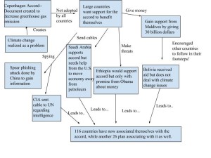
2.) For my diagram, I wanted to focus on the interactions between the cables, climate change, and their effect on gaining support for the Copenhagen Accord. The article describes how large countries such as the United States wanted the accord to be officially adopted as it encourages each nation to focus on a way to reduce greenhouse gases. As a result, it allows for easier access to bind to rapidly growing countries than the process proposed by the United Nations. So, I started my diagram by explaining how climate change encouraged the creation of the Copenhagen Accord. Many countries did not support the accord, so it pushed the U.S. to find ways to gain their approval of it. I decided to break down the different ways the U.S. fought to change the opinions of these countries. They used spying, cables, money, and threats to encourage countries to join the Copenhagen Accord. There were several countries mentioned throughout the article, so I decided to group them based on how their opinions were manipulated by the U.S. (Saudi Arabia, Ethiopia, Maldives, and others). Finally, each country involved in the accord must commit to some change within their country to reduce greenhouse gases. Many countries agreed to make a change, so I tied the entire diagram together by showing how over one hundred and sixteen countries decided to support the accord. Another twenty-six countries plan on committing to the accord later in time as well. The various means of encouraging support performed by the United States seemed to have worked!

3.) After reading the article, I believe the cable leak makes climate change collective action more difficult than before. Collective action in terms of climate change requires groups to make a change together to reduce emissions, even though the individual might want to emit more gasses. The article discusses America’s means of bribing other countries to support the accord, including giving countries financial aid. Many countries might not want to change or reduce their emissions, but they are doing it for the money. As soon as the money is removed, the country might stop their efforts to save the environment. It is similar to the idea of carbon offsetting! Companies pay people to reduce their emissions. Yet, people may need money to motivate them to reduce their carbon footprint on their own. Countries and individuals need to find it in themselves to reduce emissions because it can affect the future of our world. They need to realize climate change creates issues with plant life and how they adapt to rising temperatures, rising water levels due to melting, and even humans! So, they should voluntarily want to help and not be manipulated by our country to do so. It may have been frustrating for the United States to see other countries not willing to support the accord. Yet, I do not think it is right to force countries through threats to agree to it. Conversations about why they would not agree or what they believe should be done might have been more successful than manipulation of their beliefs. Allowing for countries which are near each other to have conversations about what they can do to decrease greenhouse emissions might be easier than having the whole world try to communicate. It might allow for countries nearby to work with one another to mitigate the effects of climate change in their area.

Natural Hazards–Amanda Giedroc

  1. State College is located in central Pennsylvania. According to the Nathan World Map of Natural Hazards, my town is situated in Zone 2 for Hailstorms. The area is prone to heavy rainfall due to storms during the winter and summer. State College is situated in Zone 0 for Extratropical storms, with wind speed less than or equal to 80 miles per hour. The area does not frequently encounter tornadoes or wildfires and is located in Zone 1 for both. The Nathan map is great for looking at natural hazards at a global scale. It would be easier to view the data and draw conclusions if the maps were produced on a smaller scale. I had to guess the location of my town on the map and which zone the town was in for multiple hazards.
  2. According to the RSOE EIS map, a 4.3 magnitude earthquake in Taitung City, Taiwan occurred today at 8:08 am (UTC time). The hazard is not likely to occur in State College as my town is not located near any fault lines. The Nathan map puts my town in Zone 0: MM V and below for earthquakes. On the other hand, Taiwan is located in Zone 3 and 4 for earthquakes on the Nathan map. The country is situated near tectonic plates which continually collide together producing earthquakes. The scale and number of people affected was not found in the details, but I would assume the hazard would affect many people and be at a national scale as Taiwan is relatively small. If the earthquake were to occur in State College, the results would be devastating as it would be at a local or smaller scale. The earthquake would be stronger and would lead to some more vulnerable than others depending on their location. Those who live on the outskirts of town would be less vulnerable to the earthquake as it might be weaker if the center occurred in State College. People who live in poorly built buildings or who live downtown might be more vulnerable as more debris could fall and hit them. Citizens who are young and live in open areas would be the least vulnerable as they would be able to protect themselves from danger. My town could reduce their vulnerability to earthquakes by educating citizens on what to do if they occur. Having a response plan to aid those who are hurt or affected by the earthquake would be beneficial as people could be treated quickly. It could fix the damages in the town as fast as possible.
  3. I have lived in State College for my entire life and have experienced a handful of natural hazards. The area frequently endures severe thunderstorms and snowstorms. Several thunderstorms in the past have been so severe they led to a tornado warning. A few tornadoes have touched down near State College, but they were not very strong. Snowstorms have been present in my area, with totals exceeding 30 inches according to my father. In some cases, snow squalls have appeared during the winter which creates dangerous conditions for drivers. The area is not prone to earthquakes and volcanoes. Occasionally, the area may get hit with rain and winds from a hurricane coming off the Atlantic Ocean. Overall, central Pennsylvania is very safe compared to other regions throughout the country.
  4. State College normally experiences thunderstorms and snowstorms throughout the year. I think educating people about these types of storms could help to reduce the damage done by them. In particular, improving the technology to communicate ideas related to weather problems would be important as well. For example, there is little communication regarding the presence of snow squalls. Most citizens do not know when or where they will occur. It would be great to educate people about the severity of snow squalls and to give them an idea of when they will occur. As a result, it could save the lives of many people driving on the highways or nearby areas. PennDot and AccuWeather would be the best people to perform these actions as they have the knowledge and skills needed to educate people about these hazards. Accuweather can inform people of the hazards while PennDot can educate and implement these actions. As a citizen of State College, I can create a plan with my neighbors to prepare and respond to natural hazards. I might designate a neighbor to have extra food available, to have extra batteries, and to have blankets in case we lose power due to a hazard. As a result, we could prepare and survive for all natural hazards which may occur in our area.

Module 7–Amanda Giedroc

My town is State College, PA and I have lived there for my entire life. The majority of the town is filled with automobile suburbs (I live in one). Most stores and shops are about a fifteen minute walk away. Yet, it is easier to drive as sidewalks are not always available. CATA buses stop at a few of these neighborhoods, providing an additional way to travel around town. State College has a few pedestrian-oriented neighborhoods near the center of town as well. Many college students live in these areas and walk to work or campus every day. Around 41,000 people live in State College year round. The number does not include Penn State students. The urban density of the town is fairly low, with most buildings around three stories high. The downtown area is largely mixed use as stores, restaurants, churches, and school buildings are near one another. I was born in State College and have seen the development of the town required to meet the needs of the population.

The city of Curitiba is similar to State College as they both have a working bus system. State College uses the CATA bus system to transport people to different locations around town. The city of Curitiba uses their bus system to transport roughly 2.3 million people to and from the city on a daily basis. I think State College could change their bus system to make it more efficient and to reduce pollution. The buses in Curitiba have double corridors and they run to locations outside of the city. If State College had double corridor buses, they could transport more people in a shorter amount of time. They could reduce the number of buses on the road, leading to a decrease in pollution as well. Additionally, if the CATA bus system extended their routes further into outlying neighborhoods, more citizens would have access to buses. They would not have to drive their car to work or around town every day. As a result, more people would ride the bus, thus discouraging pollution and congestion.

The urban agriculture found in Detroit can be related to State College as well. Detroit emphasized farming as a way citizens could increase their food and income. Many citizens around State College grow their own food by planting gardens in their backyards. The town is not located in a food desert, because citizens have access to fresh produce. Yet, I think State College could encourage citizens to grow more of their own produce. In Detroit, farmers sell their fruits and vegetables at a farmers market. Citizens of State College have access to these markets downtown. Sadly, these markets are not usually held in the outlying areas of town. It would be great to have communities set up their own farmers market. People could bring their own produce to sell to neighbors in their area. Additionally, it might be a good idea to encourage small communities to grow food together. It would allow for people to work together to create a more sustainable future for State College and their neighborhood.

Social Norms and Food Choices

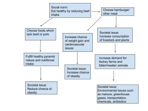
1.) My food choice was affected by the social norms of my friends a few weeks ago. We all decided to go to a small restaurant to relax after a tough week. When it came time to order food, my friends ordered a salad, fish, and vegetable soup. They wanted to eat healthier by limiting the amount of beef and pork in their diet. I personally wanted a juicy burger with a side of cheese fries. I began to feel uncomfortable knowing all of my friends wanted to eat healthy while I wanted to order an unhealthy meal full of meat. As a result, I decided to settle for chicken noodle soup (not the healthiest thing there) even though it was not something I craved. Eating healthy meals full of nutrients and reducing the intake of meat was a social norm they had adapted. By not following the norm, I felt separated from the group and uncomfortable with my decision. So, I changed my order to fit in with the social norms created by my friends.

2.) My food choice can be directly related to the societal issues of obesity and livestock. In Module 6, we learned about the prominence of obesity in our society today. Eating beef and pork have been linked to weight gain and cardiovascular issues such as high blood pressure. One can reduce their chance of obesity by ordering meals which resemble the food pyramid (less meat) and exercising. By adapting to the social norm, I chose a healthier meal which increased my energy and nutrient intake. Additionally, we learned in Module 6 about the effects of livestock on the environment. By eating healthier and limiting our consumption of meat, my friends and I made an attempt to create a small decrease in the pollutants, greenhouse gases and diseases produced. I decided to follow the social norms of my friends by choosing not to eat meat in order to help my health and the environment. The social norm should be changed to include more fruits and vegetable in meals while reducing the intake of beef as well.

3.)

arg5492 (2)


Congestion and Poverty Case Studies

The first case study comes from the Colby-Sustainable Development website. The article, “Pricing Traffic Congestion”, describes the crowding of traffic in London, England. The congestion leads to an increase in pollution near the cities. In order to solve these problems, London implemented a congestion charge. Any person who drives into central London from 7:00 am to 6:30 pm, Monday through Friday, must pay 8 pounds. As a result, people have been using the bus system to travel into the city, which reduces the number of vehicles on the road and pollution. This kind of development may only be available to those who live in countries which have a high gross income and GDP. Those who live in the lower classes of London might not have the luxury to travel downtown because they cannot afford the charge. Additionally, England needs to have a stable economy in order to cover the costs of the system. Some countries may not have the flexibility to spend government money on patrolling the congestion charges of its citizens. Link: http://personal.colby.edu/personal/t/thtieten/Allison.htm

The second case study comes the Center for Global Development website. The article, “Improving the Health of the Poor in Mexico”, describes an attempt to reduce illness, low birth weights, infant mortality, and poor nutrition of the poor in Mexico. The program, Oportunidades, involves the Mexican government giving participants financial support. Then, the family uses the money to take their children to the doctors or to send them to school. Participants also have access to nutrition counseling and supplementary foods. In Module 5, we learned one way to view development is to look at the health statistics of a nation. Mexico is continuing to improve their health statistics with the program Oportunidades, thus developing into a better country. Additionally, the case study can be related to Hans Rosling’s TED talk. Many of us have might believe child mortality rates are not very high. Oportunidades is attempting to fix this misconception by bringing to light the problem and solution to the high death rate and poverty of its children. Link: http://www.cgdev.org/page/case-9-improving-health-poor-mexico.

The two case studies I have discussed are related to the development in my home town of State College, PA. The first case study is related as certain roads are known for being congested in my town. Atherton Street and Park Avenue are congested nearly every day. However, the congestion is much worse in major cities than in State College. Residents of my town are encouraged to ride their bikes or take the bus as much as possible. Yet, citizens still drive all the time. We should make more of an effort to conserve our environment by riding a bus or bike. The second case study can relate to my town as well. State College contains a small group of poor citizens. A program similar to Oportunidades would most likely flourish as many families don’t have access to food or shelter. The money would probably come from the state or local level as the government might not be willing to participate. The program would encourage lower class citizens to live a healthier and productive life.

Water Tracking in State College–Amanda Giedroc

1a.) My home in State College, PA receives water from two different wells. The first well is located at Spring Creek Park, while the second is located on the corner of Shiloh Road. Both wells pump water up from the ground and distribute it to nearby houses. Once the water leaves my house, it travels to the University Area Joint Authority (UAJA). When the water arrives, it goes through a series of clarifiers, splitters, and tanks until it reaches the ANT building. In the building, chemicals are added to the water to make it clean. UAJA adds chlorine gas, 5 mL of oxygen, ozone, and UV light to kill all microorganisms. Later in the cycle, water is pushed through screens which catch minute particles. Once it is clean, the water is pumped back into Spring Creek (where it can be distributed back into homes) or pumped to specific areas in town such as the car wash, CINTAS, and the Center Hills Country Club. UAJA guides water to local wetland areas as well.

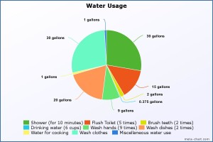
1b.) TOTAL WATER USAGE: 111.375 gallons

meta-chart

1c.) Living on two gallons of water for a day was nearly impossible for me. I put my two gallons of water towards drinking, washing my hands, and flushing the toilet. The majority of my water use was dedicated to drinking as I get massive headaches if I am not hydrated. I took a little bit of water to brush my teeth and to wash my hands. I did not take a shower, cook (I ordered food from a nearby restaurant), or do a single load of laundry. In order to cut back on my water footprint, I did not leave the water running while I brushed my teeth, or while washing my hands. I waited until it was absolutely necessary to flush the toilet as well. After the day was over, I realized I failed at this experiment. By three o’clock I had used up my two gallons of water. Living off of two gallons of water was miserable considering I use 111 gallons on a daily basis. The experiment put into perspective the different ways I can cut down the amount of water I use in part 1b. Geography matters to water use as certain areas around the world have a limited amount of water. As a result, areas such as Haiti have to use very little water on a daily basis in order to sustain it. I am grateful to live in a town where water is easily accessible!

Ethics–Amanda Giedroc

#1. Is it more important to be a good person or to perform good acts (virtue ethics vs. action ethics)?

I think it is more important to perform good acts (virtue ethics) than to be a good person. Those who perform good acts generally do so because they want to make a difference. For example, an onlooker might observe a man holding open a door for an elderly woman as she walks through. The onlooker may come to a conclusion the man is nice because he performed a good act. Good acts give people the power to make a difference in the community and environment. By performing good acts, a sense of positivity is shared by everyone involved. The person committing the act feels good about themselves, and the receiver of the action may feel thankful. In some cases, a good person can perform a bad act. Let’s say a good person is late for work and they get into an accident. Instead of stopping, they drive off feeling overwhelmed. The person may be good, but their actions do not reflect it. Many people claim actions speak louder than words. Performing good acts show the goodness of someone. Claiming to be a good person without showing it is difficult to believe. As a result, good acts both help society and the person performing them.

#3. Does the process by which decisions are made matter more than the outcomes of these decisions (procedural justice vs. distributive justice)?

I believe the decision-making process matters more than the outcome (procedural justice). The process is vital in creating a sense of unity among a group of people. Giving people the chance to express their opinions can make them feel as if they made a contribution to the process (democracy). Those who take part in the process might be open to listening to the opinions of others as well. Contrasting opinions can help people to see the benefit of another solution or how they can improve their own idea. Additionally, the decision-making process can be used to brainstorm new ideas. People can bounce ideas off of one another or try to figure out a new way to solve the problem. In some cases, the outcome is more important than the process. If the decision is bad or does not reflect the group’s opinion, then the process does not matter. Somewhere along the line, the process got messed up. Overall, the decision-making process matters more because it allows for brainstorming, debating, and a sense of unity.

#6. Is my own life worth more than the lives of others, the same, or less (selfishness vs. altruism)?

I believe my life is worth the same as the lives of others. Every human being on the planet is unique in what they bring to our world. My ideas, lifestyle choices and traits are specific to my life. They are not better than the traits and lifestyles choices of another person. What I do with my life is just as important as what my neighbor does with his own. In some situations, my life might be more important than the lives of others (selfishness). My life would hold more importance in comparison to the life of a terrorist or criminal. They have lived their lives in a negative way which has hurt others. They have ruined their chance at making a difference in the world while I still have the freedom to do so. On the other hand, my life is less important than the life of a small child or baby (altruism). When it comes down to it, babies are the only way we can carry on our genes. They need to stay alive long enough to reproduce, and to have a chance at creating a life for themselves. Despite these specific cases, I believe my life is worth the same as others. All humans are equal, so there is no reason why my life is not equal to the life of another person.

Biogas–Amanda Giedroc

SOCIAL SYSTEM                ECOSYSTEM

biogas_arg5492

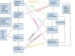
In my diagram, I wanted to focus on the coupled human-environment interactions in more detail. For example, I thought it was important to discuss the effects of picking up wood on education and deforestation. By looking at the systems in more detail, I noticed some positive and negative feedback loops. In terms of the economy, biogas generators produce fertilizer which the women in the town can sell. Due to the increase in money, more families can buy more generators, leading to even, more money (positive feedback loop). On the other hand, biogas generators push families away from picking up branches, leading to a decrease in deforestation (negative feedback loop). As I compared my diagram to Marten’s in the reading, I noticed we had some things in common. We both discussed farms, forests, fertilizer and cooking oil. However, in my diagram, I focused on the problems associated with health, education, and the economy. Additionally, we differed as I did not have branches discussing the human population and how generators could affect the number of children families had. There are similarities between our diagrams because we both mentioned crucial points about the purpose and significance of biogas generators. However, there are differences because I spent more time breaking down the relationships in great detail while Marten made the important broad connections. By comparing the two diagrams, viewers might not have thought about how biogas generators can increase wealth (economy) for women and farmers in the town.

Learning Activity–Amanda Giedroc

Hello everyone! My name is Amanda Giedroc and I’m currently taking the class from State College, PA. I was born and raised there as well. I’m majoring in elementary education and taking classes to be certified to teach ESL students. After I graduate, I hope to teach at the elementary school I went to as a child and to pursue additional certifications in math education. I am taking this course to fulfill a graduation requirement, but also to increase my knowledge about geography. The geography classes I took in high school dealt strictly with looking at maps and pointing out different places. As I result, I have little exposure to the different kinds of geography and how it is impacted by the environment. I am excited to learn about how humans affect the environment and environmental governance.

With the completion of module one, I realized there are many issues that geography would be able to solve. The first issue I thought of was related to the spread of diseases. In my microbiology class, we discuss the importance of containing diseases so they do not infect other people. In my mind, geographers might look at the scale in which the disease has spread. For example, they could look at the amount of people who have become sick at a local level with a specific virus and then at a national level to see if it has been contained. Maps which are projected to look at a tiny area of a city (the London underground system map) might help health officials to target a specific area where the disease started. People would need to report their symptoms to a doctor with their location, so geographers could effectively look at the extent to which it is spread and so they can create a plan to help people feel better.